

LightMamba: A Lightweight Mamba Network for the Joint Classification of HSI and LiDAR Data
-
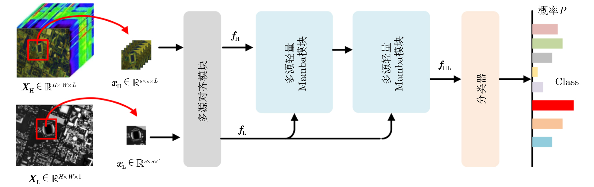
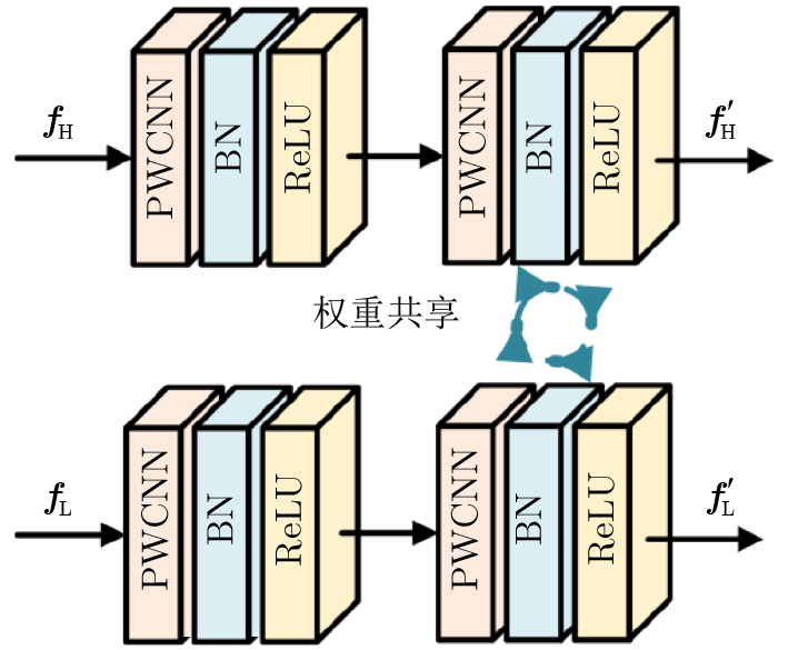
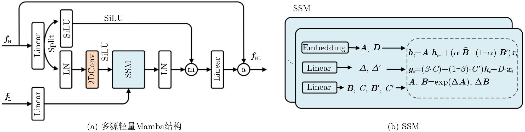
摘要: 高光谱图像(HSI)和激光雷达(LiDAR)数据的联合分类是遥感领域的一项关键任务,它通过融合丰富的光谱信息和精确的三维结构信息,显著提升了对地物识别的精度。然而,现有的基于深度学习(DL)的联合分类方法依然受限于高模型计算复杂度。因此,该文提出一种新颖的轻量级Mamba网络。该网络的核心是引入了先进的状态空间模型(SSM),其线性计算复杂度特性使其能够高效地建模遥感数据中的长距离上下文依赖关系。首先,多源对齐模块被用于对异构的HSI和LiDAR数据进行特征提取与空间-光谱维对齐,以提供一致的特征表示;其次,多源轻量Mamba模块以LiDAR的高程信息作为引导,采用轻量化设计融合双流序列,高效建模长距离依赖;最后,设计了一种基于MLP的分类器,并输出分类结果。在多个公开基准数据集上的实验结果表明,与当前先进方法相比,LightMamba在分类精度上取得了显著提升,同时保持了更低的计算复杂度,证明了基于Mamba的架构在遥感多源数据融合与分类任务中的巨大潜力。LightMamba的代码可访问
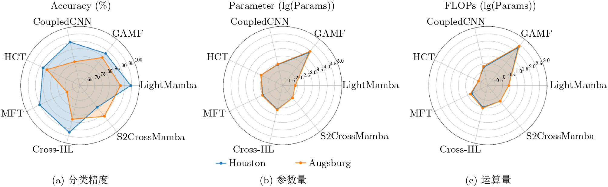
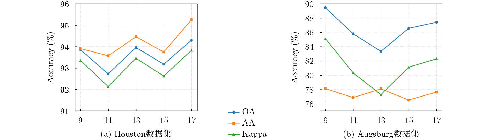
https://www.scidb.cn/detail?dataSetId=064dc4ac5350418e87a8b82dd324737b&version=V1&code=j00173 。Abstract:Objective The joint classification of HyperSpectral Imagery (HSI) and Light Detection And Ranging (LiDAR) data is a critical task in remote sensing, where complementary spectral and spatial information is exploited to improve land cover recognition accuracy. However, mainstream deep learning approaches, particularly those based on Convolutional Neural Networks (CNNs) and Transformers, are constrained by high computational cost and limited efficiency in modeling long-range dependencies. CNN-based methods are effective for local feature extraction but suffer from limited receptive fields and increased parameter counts when scaled. Transformer architectures provide global context modeling but incur quadratic computational complexity due to self-attention mechanisms, which leads to prohibitive costs when processing high-dimensional remote sensing data. To address these limitations, a lightweight network architecture named LightMamba is proposed. The model leverages an advanced State Space Model (SSM) to achieve efficient and accurate joint classification of HSI and LiDAR data. The objective is to maintain linear computational complexity while effectively fusing multi-source features and capturing global contextual relationships, thereby supporting resource-constrained applications without accuracy degradation. Methods The proposed LightMamba framework consists of three core components. First, a MultiSource Alignment Module (MSAM) is designed to address heterogeneity between HSI and LiDAR data. A dual-branch network with shared weights projects both modalities into a unified feature space, which ensures consistent spatial-spectral representation. This shared-weight strategy reduces the parameter count and strengthens inter-modal correlation through the learning of common foundational features. Second, the Multi-Source Lightweight Mamba Module (MSLMM) forms the core of the framework. Aligned HSI and LiDAR feature sequences are processed using a parameter-efficient Mamba architecture. A hybrid parameter-sharing strategy is adopted by combining shared matrices with modality-specific parameters, which preserves discriminative capability while reducing redundancy. LiDAR elevation information is used as a positional guide to enhance spatial awareness during feature fusion. The selective scanning mechanism of the SSM enables efficient modeling of long-range dependencies with linear complexity, thereby avoiding the quadratic cost associated with Transformers. Spectral bands are processed sequentially to preserve joint spectral spatial characteristics. Finally, a MultiLayer Perceptron (MLP)-based classifier maps fused high-level features to class probabilities with low computational overhead. The model is trained end to end using cross-entropy loss. Evaluations are conducted on two public benchmarks, namely the Houston and Augsburg datasets. Comparisons are performed against representative methods, including CoupledCNN, GAMF, HCT, MFT, Cross-HL, and S2CrossMamba, using Overall Accuracy (OA), Average Accuracy (AA), and the Kappa coefficient. Ablation experiments analyze the contribution of each module, and parameter count and FLoating-Point Operations (FLOPs) are reported. Results and Discussions Experimental results demonstrate that LightMamba achieves superior performance and efficiency. On the Houston dataset, an OA of 94.30%, an AA of 95.25%, and a Kappa coefficient of 93.83% are obtained, which exceed those of all comparison methods. Perfect classification accuracy is achieved for several classes, including Soil and Water. Classification maps exhibit improved spatial continuity and internal consistency, with reduced speckle noise, particularly in heterogeneous regions such as commercial areas. On the Augsburg dataset, LightMamba achieves the highest OA of 87.41% and a Kappa coefficient of 82.30%, which confirms strong generalization across different scenes. Although the AA is slightly lower than that of S2CrossMamba, the higher OA and Kappa values indicate better overall performance. Complexity analysis shows that LightMamba attains high accuracy with a lightweight structure containing only 69.93 k parameters, which is substantially fewer than GAMF and comparable to S2CrossMamba, while maintaining moderate FLOPs. Experiments on input patch size indicate adaptability to scene characteristics, with optimal performance observed at 17×17 for the Houston dataset and 9×9 for the Augsburg dataset. Conclusions A lightweight network architecture, LightMamba, is presented for joint HSI and LiDAR classification. By combining a shared-weight MSAM with a lightweight Mamba module that adopts hybrid parameterization and elevation-guided fusion, modal heterogeneity is effectively addressed and long-range contextual dependencies are captured with linear computational complexity. Experimental results on public benchmarks demonstrate state-of-the-art classification accuracy with a reduced parameter count and computational cost compared with existing methods. These findings confirm the potential of Mamba-based architectures for efficient multi-source remote sensing data fusion. Future research will explore optimized two-dimensional scanning mechanisms and adaptive scanning strategies to further improve feature capture efficiency and classification performance. The LightMamba code is available at https://www.scidb.cn/detail?dataSetId=064dc4ac5350418e87a8b82dd324737b&version=V1&code=j00173 . -
表 1 两种数据集详细信息
类别 Houston Augsburg 名称 训练 测试 名称 训练 测试 C1 健康草地 20 1231 林地 20 13487 C2 受胁迫草地 20 1234 住宅区 20 30309 C3 人造草地 20 677 工业区 20 3831 C4 树木 20 1224 低矮植被 20 26837 C5 土壤 20 1222 社区园地 20 555 C6 水体 20 305 商业区 20 1625 C7 住宅区 20 1248 水体 20 1510 C8 商业区 20 1224 C9 普通道路 20 1232 C10 高速公路 20 1207 C11 铁路 20 1215 C12 停车场1 20 1213 C13 停车场2 20 449 C14 网球场 20 408 C15 塑胶跑道 20 640 - 总计 300 14729 总计 140 78154  下载: 导出CSV
表 2 LightMamba方法中不同模块对分类精度OA值的影响
情况 组成成分 Houston Augsburg MSAM 1个MSLMM 2个MSLMM OA(%) OA(%) 1 √ 81.28 75.96 2 √ √ 93.86 85.50 3 √ √ 94.30 87.41
下载: 导出CSV
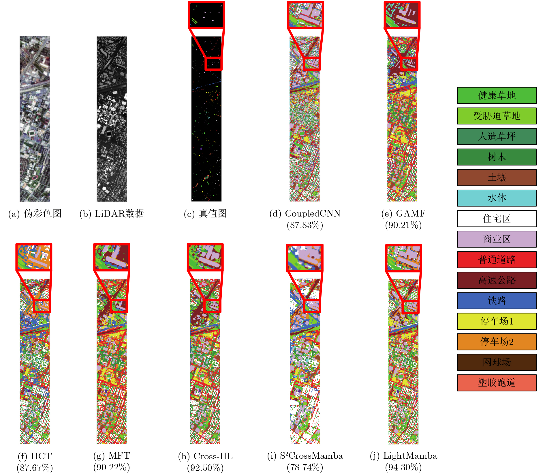
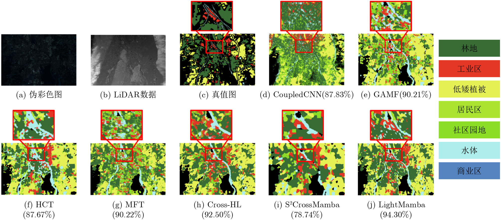
表 3 对Houston数据集采用不同方法获得的分类结果进行比较(最佳结果以粗体显示)(%)
类别 HSI+LiDAR 本文方法 CoupledCNN GAMF HCT MFT Cross-HL S2CrossMamba LightMamba C1 93.01 99.59 92.93 96.91 97.97 90.75 94.55 C2 96.68 97.33 98.62 94.97 89.87 98.68 93.67 C3 99.85 99.85 99.85 100 98.82 99.69 99.11 C4 88.23 93.87 99.34 91.33 99.75 96.01 94.52 C5 95.49 99.67 99.67 97.70 100 99.75 100 C6 97.70 92.13 98.68 100 94.09 100 100 C7 81.33 81.41 98.71 76.84 91.51 39.49 91.34 C8 83.00 85.94 76.87 71.32 77.04 96.84 86.68 C9 70.86 79.38 76.13 82.22 85.95 28.05 90.58 C10 80.19 74.15 68.68 94.03 97.10 74.22 94.11 C11 89.62 87.48 94.89 89.95 81.64 88.20 97.36 C12 79.22 87.88 46.66 92.82 92.91 44.42 90.51 C13 82.20 93.76 97.55 98.44 95.32 100 96.21 C14 100 99.26 100 99.26 100 99.74 100 C15 98.90 100 99.37 91.09 100 80.32 100 OA 87.83 90.21 87.67 90.22 92.50 78.74 94.30 AA 89.76 91.45 89.87 91.80 93.47 82.41 95.25 K×100 86.86 89.41 86.69 89.43 91.90 77.23 93.83
下载: 导出CSV
表 4 对Augsburg数据集采用不同方法获得的分类结果进行比较(最佳结果以粗体显示)(%)
类别 HSI+LiDAR 本文方法 CoupledCNN GAMF HCT MFT Cross-HL S2CrossMamba LightMamba C1 96.57 94.52 95.69 92.17 96.36 96.04 92.17 C2 78.62 64.50 83.65 73.80 85.78 92.43 93.07 C3 66.56 41.00 72.95 40.17 71.86 85.66 62.85 C4 90.06 86.30 85.82 59.16 80.81 78.68 85.21 C5 89.36 98.01 96.93 64.86 69.57 90.99 87.74 C6 40.86 78.15 30.46 64.86 38.21 52.12 48.12 C7 75.76 65.43 80.66 63.97 57.08 58.54 74.43 OA 84.30 76.56 84.88 69.86 83.33 86.50 87.41 AA 76.83 75.42 78.03 65.57 66.67 79.21 77.66 K×100 78.58 69.09 79.36 60.33 76.57 81.31 82.30
下载: 导出CSV
-
[1] FAUVEL M, TARABALKA Y, BENEDIKTSSON J A, et al. Advances in spectral-spatial classification of hyperspectral images[J]. Proceedings of the IEEE, 2013, 101(3): 652–675. doi: 10.1109/jproc.2012.2197589. [2] ZHANG Xia, SUN Yanli, SHANG Kun, et al. Crop classification based on feature band set construction and object-oriented approach using hyperspectral images[J]. IEEE Journal of Selected Topics in Applied Earth Observations and Remote Sensing, 2016, 9(9): 4117–4128. doi: 10.1109/jstars.2016.2577339. [3] GHAMISI P, PLAZA J, CHEN Yushi, et al. Advanced spectral classifiers for hyperspectral images: A review[J]. IEEE Geoscience and Remote Sensing Magazine, 2017, 5(1): 8–32. doi: 10.1109/mgrs.2016.2616418. [4] PRICOPE N G, HALLS J N, DALTON E G, et al. Precision mapping of coastal wetlands: An integrated remote sensing approach using unoccupied aerial systems light detection and ranging and multispectral data[J]. Journal of Remote Sensing, 2024, 4: 0169. doi: 10.34133/remotesensing.0169. [5] SHI Cuiping, LIAO Diling, ZHANG Tianyu, et al. Hyperspectral image classification based on expansion convolution network[J]. IEEE Transactions on Geoscience and Remote Sensing, 2022, 60: 5528316. doi: 10.1109/tgrs.2022.3174015. [6] LIU Wenping, ZHANG Yuxiang, and DONG Yanni. Multifeature collaborative attention dynamic hypergraph convolutional network for hyperspectral image classification[J]. IEEE Transactions on Geoscience and Remote Sensing, 2025, 63: 5522115. doi: 10.1109/tgrs.2025.3598375. [7] LIU Quanyong, PENG Jiangtao, ZHANG Genwei, et al. Deep contrastive learning network for small-sample hyperspectral image classification[J]. Journal of Remote Sensing, 2023, 3: 0025. doi: 10.34133/remotesensing.0025. [8] ZHAO Xudong, TAO Ran, LI Wei, et al. Joint classification of hyperspectral and LiDAR data using hierarchical random walk and deep CNN architecture[J]. IEEE Transactions on Geoscience and Remote Sensing, 2020, 58(10): 7355–7370. doi: 10.1109/tgrs.2020.2982064. [9] LI Zhi, ZHENG Ke, GAO Lianru, et al. Feature reconstruction guided fusion network for hyperspectral and LiDAR classification[J]. IEEE Transactions on Geoscience and Remote Sensing, 2025, 63: 4408914. doi: 10.1109/tgrs.2025.3562246. [10] GAO Hongmin, YANG Yao, LI Chenming, et al. Multiscale residual network with mixed depthwise convolution for hyperspectral image classification[J]. IEEE Transactions on Geoscience and Remote Sensing, 2021, 59(4): 3396–3408. doi: 10.1109/tgrs.2020.3008286. [11] HONG Danfeng, HAN Zhu, YAO Jing, et al. SpectralFormer: Rethinking hyperspectral image classification with transformers[J]. IEEE Transactions on Geoscience and Remote Sensing, 2022, 60: 5518615. doi: 10.1109/tgrs.2021.3130716. [12] WANG Minhui, SUN Yaxiu, XIANG Jianhong, et al. CITNet: Convolution interaction transformer network for hyperspectral and LiDAR image classification[J]. IEEE Transactions on Geoscience and Remote Sensing, 2024, 62: 5535918. doi: 10.1109/tgrs.2024.3477965. [13] PAN Yukai, WU Nan, and JIN Wei. Multimodal feature disentangle-fusion network for hyperspectral and LiDAR data classification[J]. IEEE Geoscience and Remote Sensing Letters, 2024, 21: 5510905. doi: 10.1109/lgrs.2024.3492252. [14] ZHU Fei, SHI Cuiping, SHI Kaijie, et al. Joint classification of hyperspectral and LiDAR data using hierarchical multimodal feature aggregation-based multihead axial attention transformer[J]. IEEE Transactions on Geoscience and Remote Sensing, 2025, 63: 5503817. doi: 10.1109/tgrs.2025.3533475. [15] GU A, GOEL K, and RÉ C. Efficiently modeling long sequences with structured state spaces[C]. Proceedings of the 10th International Conference on Learning Representations, 2022. [16] HE Yan, TU Bingtu, LIU Bo, et al. HSI-MFormer: Integrating mamba and transformer experts for hyperspectral image classification[J]. IEEE Transactions on Geoscience and Remote Sensing, 2025, 63: 5621916. doi: 10.1109/tgrs.2025.3564167. [17] ZHUANG Peixian, ZHANG Xiaochen, WANG Hao, et al. FAHM: Frequency-aware hierarchical mamba for hyperspectral image classification[J]. IEEE Journal of Selected Topics in Applied Earth Observations and Remote Sensing, 2025, 18: 6299–6313. doi: 10.1109/jstars.2025.3539791. [18] LIAO Diling, WANG Qingsong, LAI Tao, et al. Joint classification of hyperspectral and LiDAR data based on mamba[J]. IEEE Transactions on Geoscience and Remote Sensing, 2024, 62: 5530915. doi: 10.1109/tgrs.2024.3459709. [19] HE Yan, TU Bing, JIANG Puzhao, et al. Classification of multisource remote sensing data using slice mamba[J]. IEEE Transactions on Geoscience and Remote Sensing, 2025, 63: 5505414. doi: 10.1109/tgrs.2025.3538553. [20] ZHANG Guanglian, ZHANG Zhanxu, DENG Jiangwei, et al. S2CrossMamba: Spatial–spectral cross-mamba for multimodal remote sensing image classification[J]. IEEE Geoscience and Remote Sensing Letters, 2024, 21: 5510705. doi: 10.1109/lgrs.2024.3488036. [21] HANG Renlong, LI Zhu, GHAMISI P, et al. Classification of hyperspectral and LiDAR data using coupled CNNs[J]. IEEE Transactions on Geoscience and Remote Sensing, 2020, 58(7): 4939–4950. doi: 10.1109/tgrs.2020.2969024. [22] CAI Jianghui, ZHANG Min, YANG Haifeng, et al. A novel graph-attention based multimodal fusion network for joint classification of hyperspectral image and LiDAR data[J]. Expert Systems with Applications, 2024, 249: 123587. doi: 10.1016/j.eswa.2024.123587. [23] ZHAO Guangrui, YE Qiaolin, SUN Len, et al. Joint classification of hyperspectral and LiDAR data using a hierarchical CNN and transformer[J]. IEEE Transactions on Geoscience and Remote Sensing, 2023, 61: 5500716. doi: 10.1109/tgrs.2022.3232498. [24] HOFFMANN D S, CLASEN K N, and DEMIR B. Transformer-based multi-modal learning for multi-label remote sensing image classification[C]. IGARSS 2023 - 2023 IEEE International Geoscience and Remote Sensing Symposium, Pasadena, USA, 2023: 4891–4894. doi: 10.1109/igarss52108.2023.10281927. [25] ROY S K, SUKUL A, JAMALI A, et al. Cross hyperspectral and LiDAR attention transformer: An extended self-attention for land use and land cover classification[J]. IEEE Transactions on Geoscience and Remote Sensing, 2024, 62: 5512815. doi: 10.1109/tgrs.2024.3374324. -

 下载:
下载:


图(7) / 表(4)
计量
- 文章访问数: 675
- HTML全文浏览量: 385
- PDF下载量: 57
- 被引次数: 0
