

Near-Field Tomographic Imaging and Coordinate Reconstruction Algorithm for Uplink Communication
-
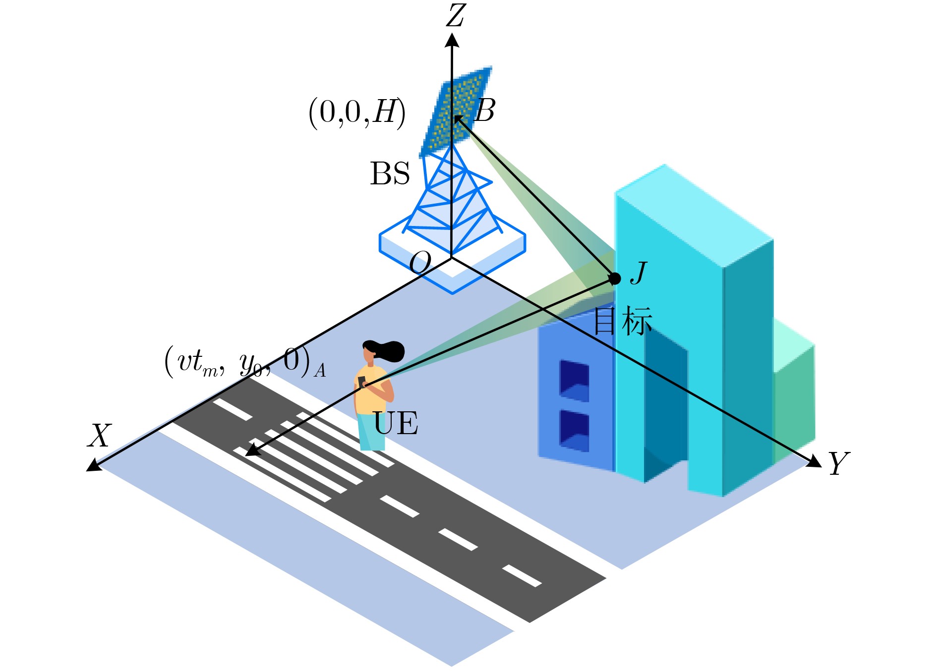
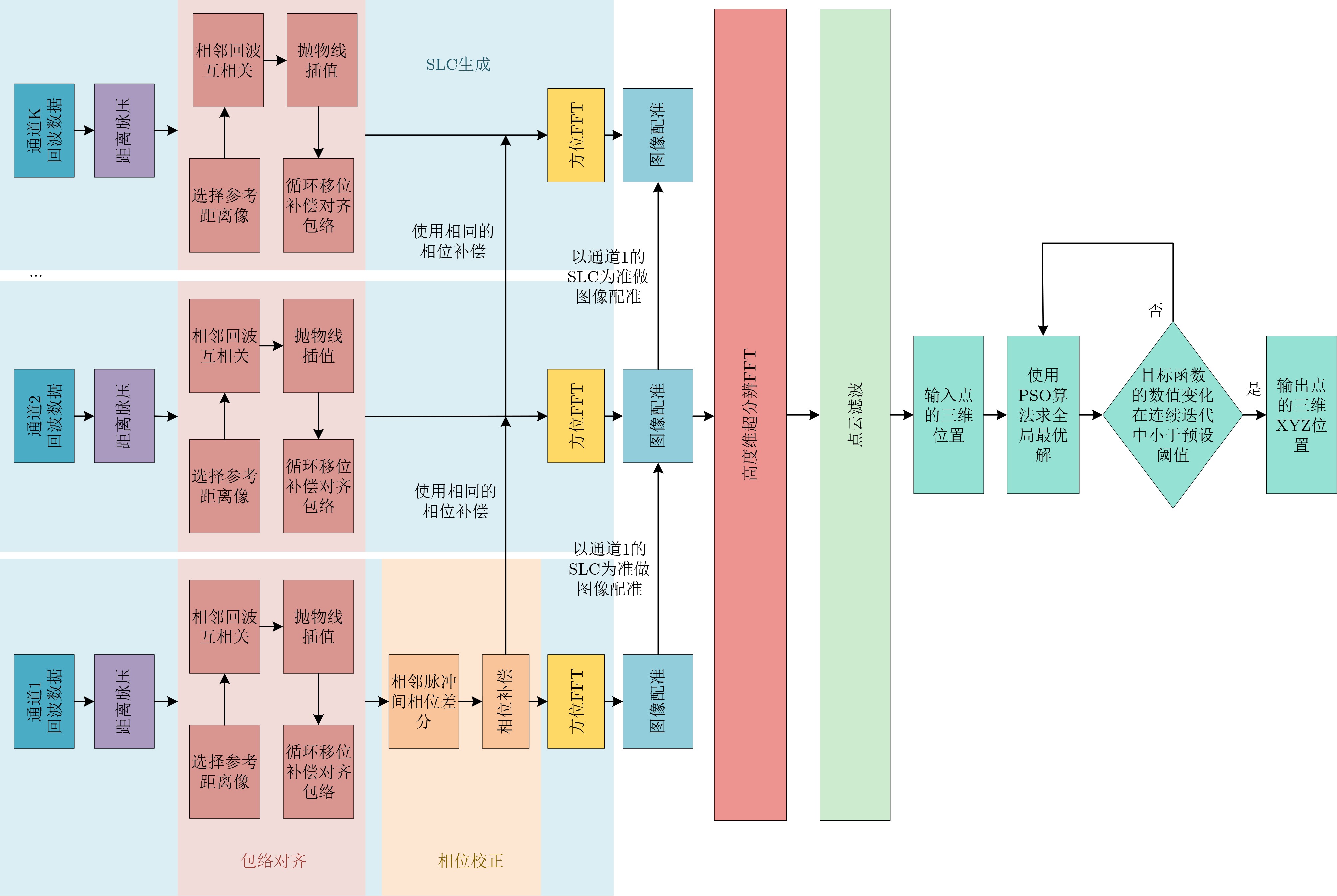
摘要: 面对日益增长的高带宽、低时延需求,6G网络技术正迅速发展, ISAC系统逐渐成为热门研究方向。环境重构作为该系统的核心环节,在实际应用中仍面临诸多挑战。该文针对以下3个问题进行了研究:(1) 在6G系统中,基站的密集部署使得建筑目标处于成像系统的近场区域,从而导致距离、方位和高度3个维度严重耦合;(2)由于终端的定位误差远大于信号波长,SAR成像中的自聚焦算法失效;(3)传统层析合成孔径雷达中各通道补偿的平动相位补偿不一致,在高度域聚焦过程中产生虚假目标。该文首先将逆合成孔径雷达成像中的非参数平动补偿方法用于单视复数图像生成,并基于双基SAR的成像场景推导出层析成像结果与目标真实空间坐标之间的数学映射关系,将坐标重构问题建模为非线性方程组,采用粒子群优化算法进行求解,实现对目标真实几何形状的精确恢复;其次,为了解决传统分通道处理中平动补偿不一致的问题,提出了一种联合相位校正的层析成像框架,可有效消除通道间的差异,显著提升了高度维聚焦效果和整体成像质量。仿真实验结果证明了该文算法的有效性。Abstract:
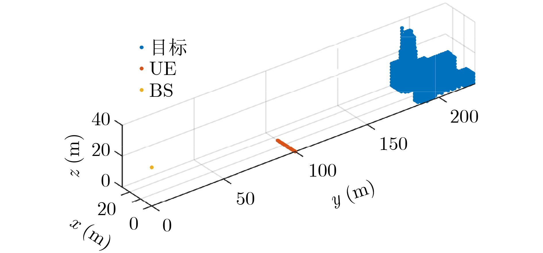
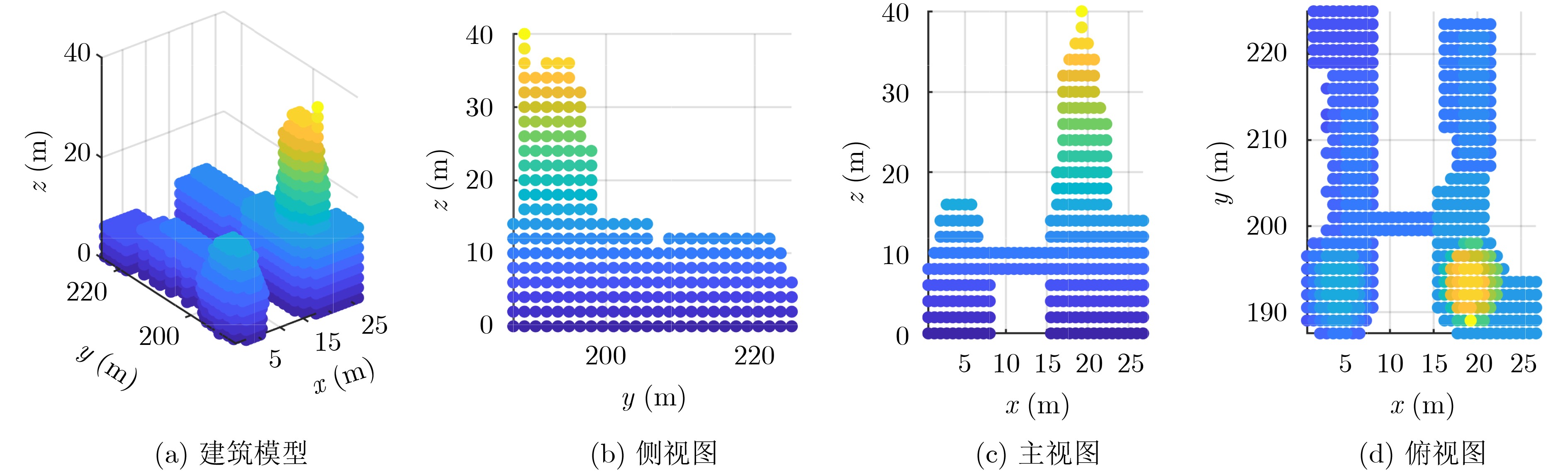
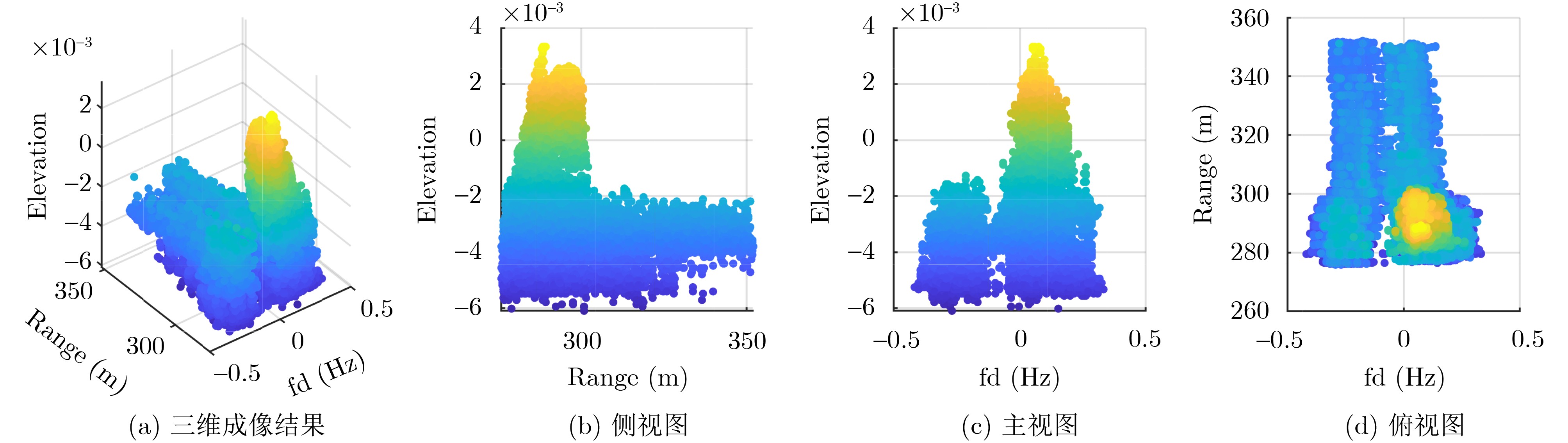
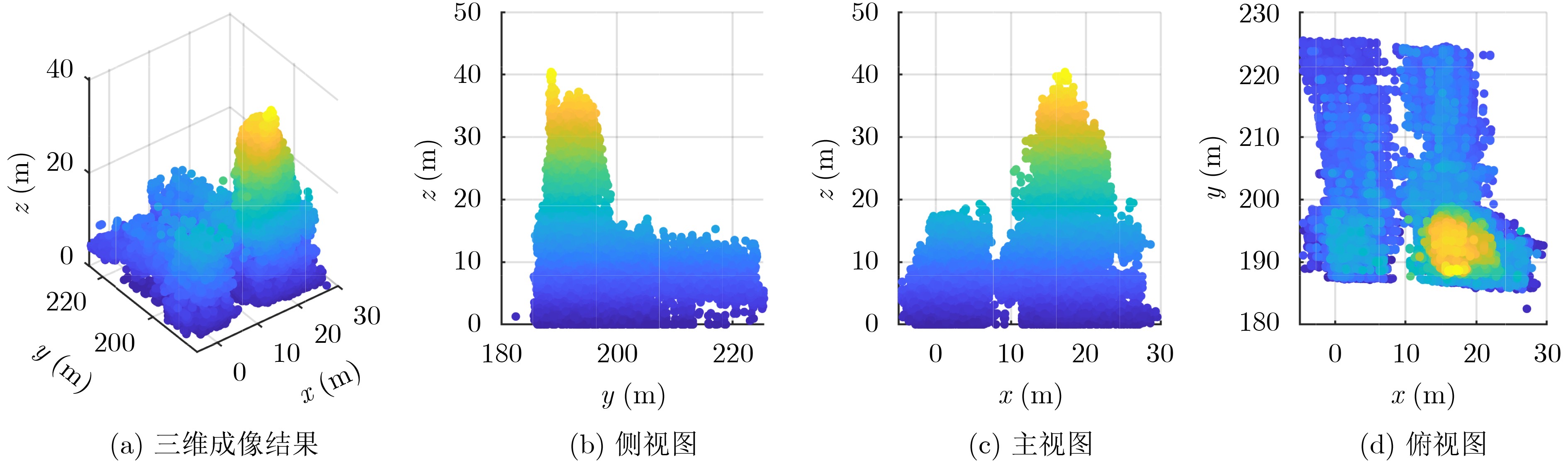
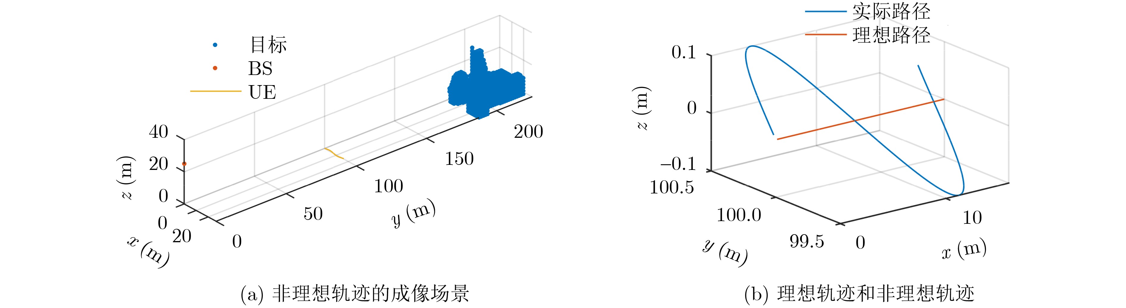
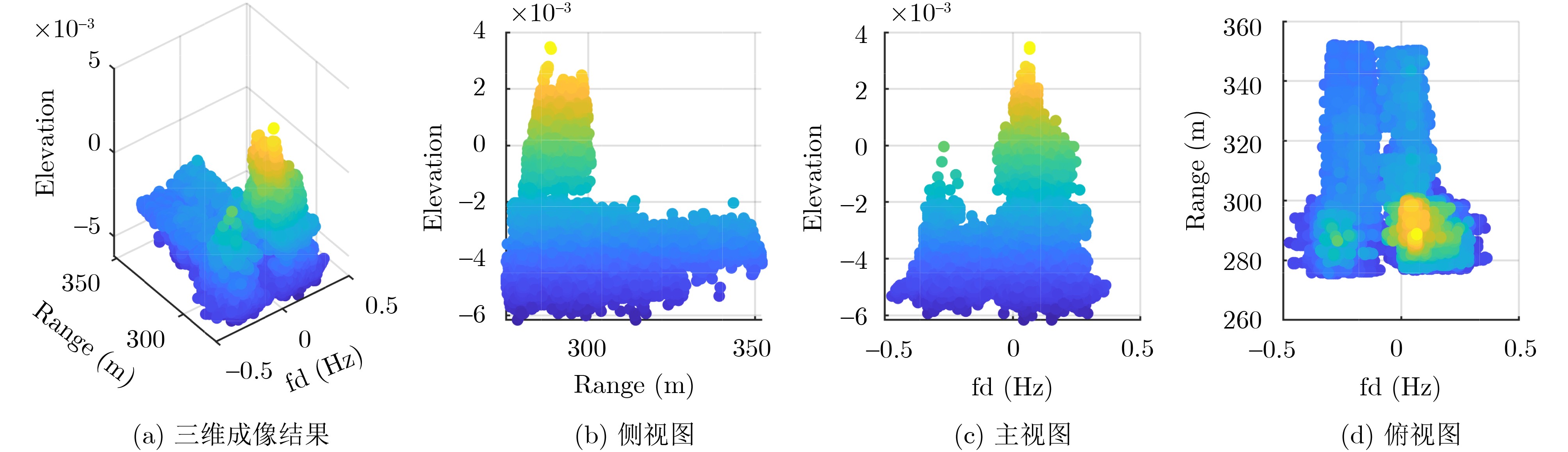
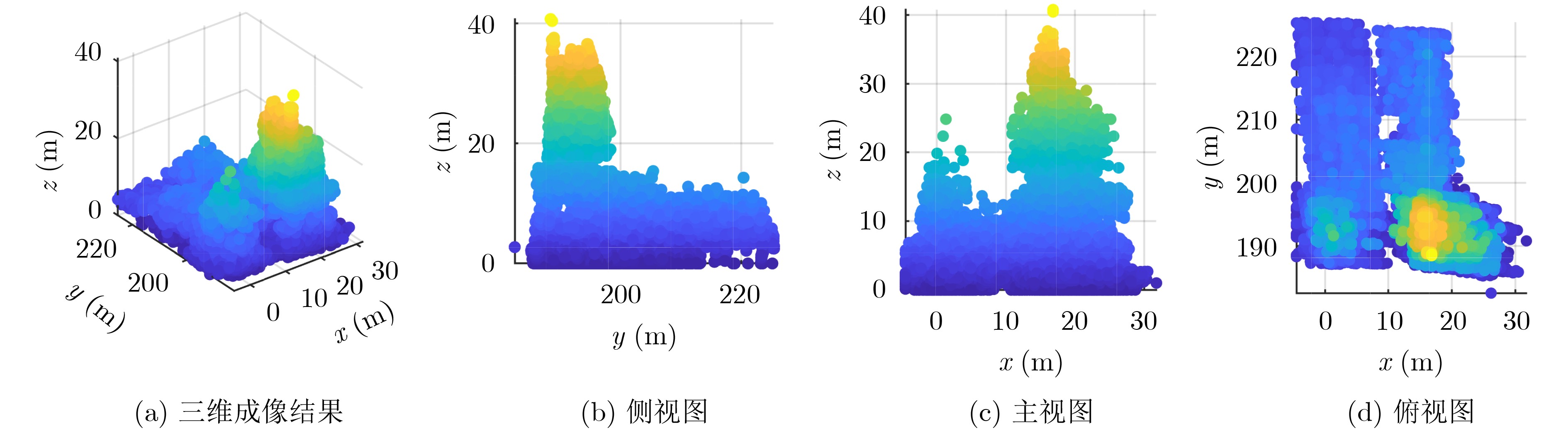
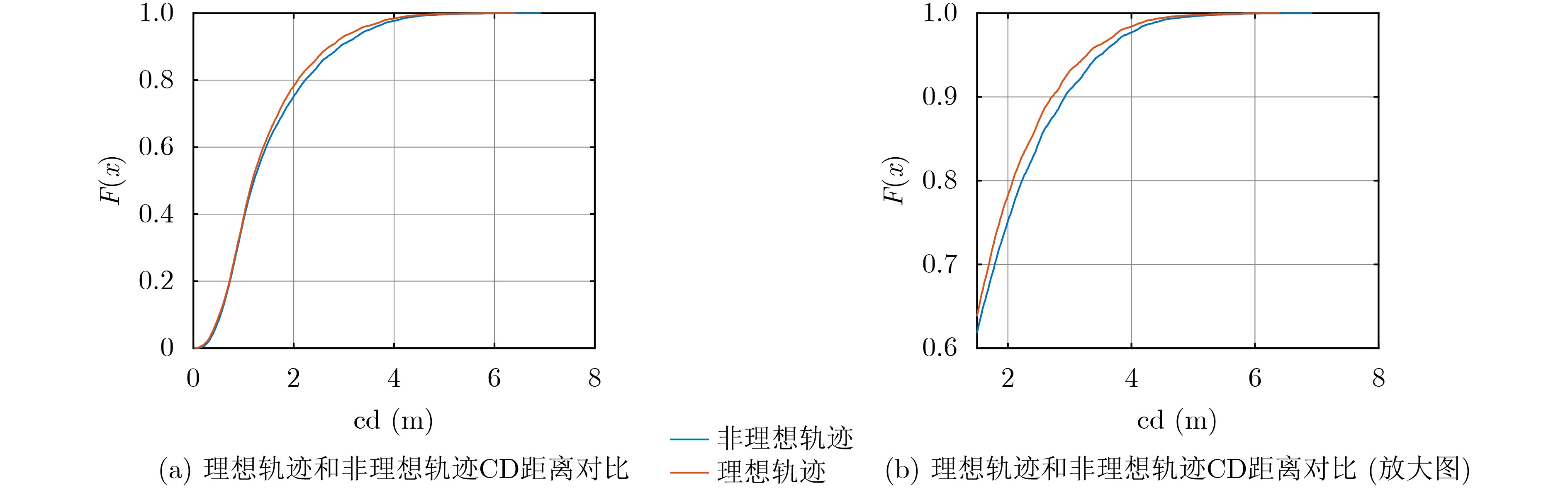
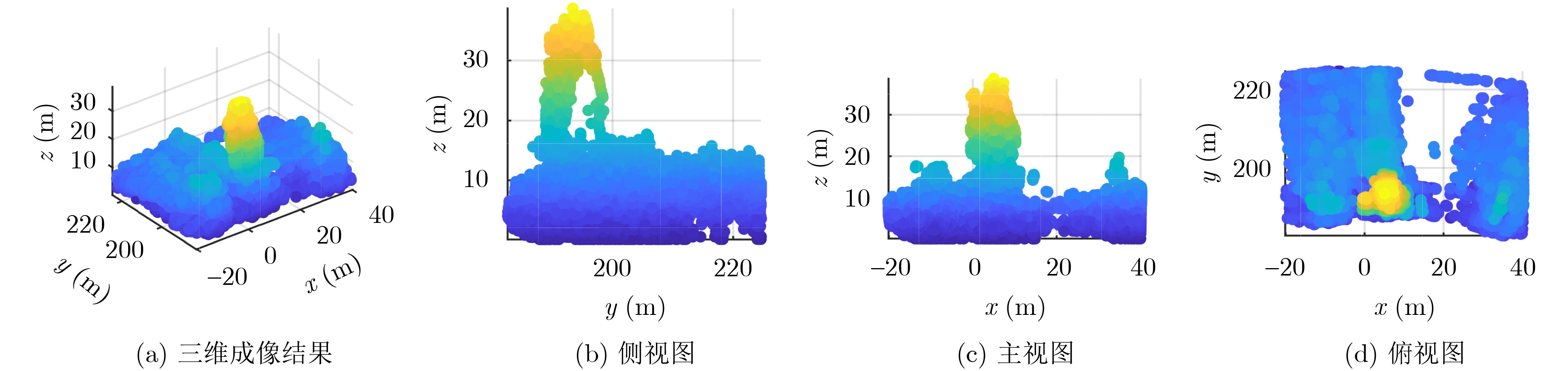
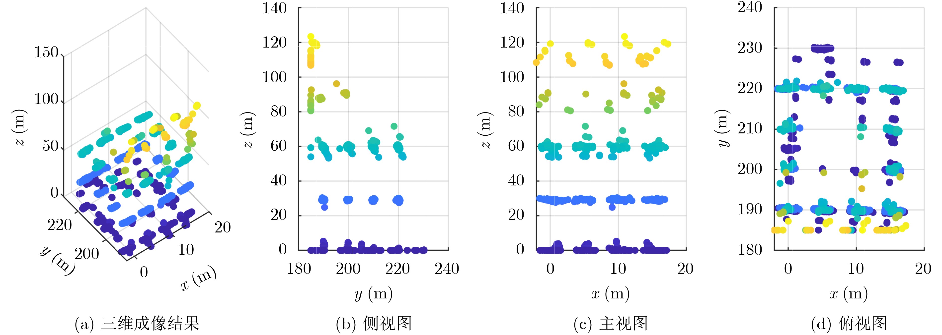
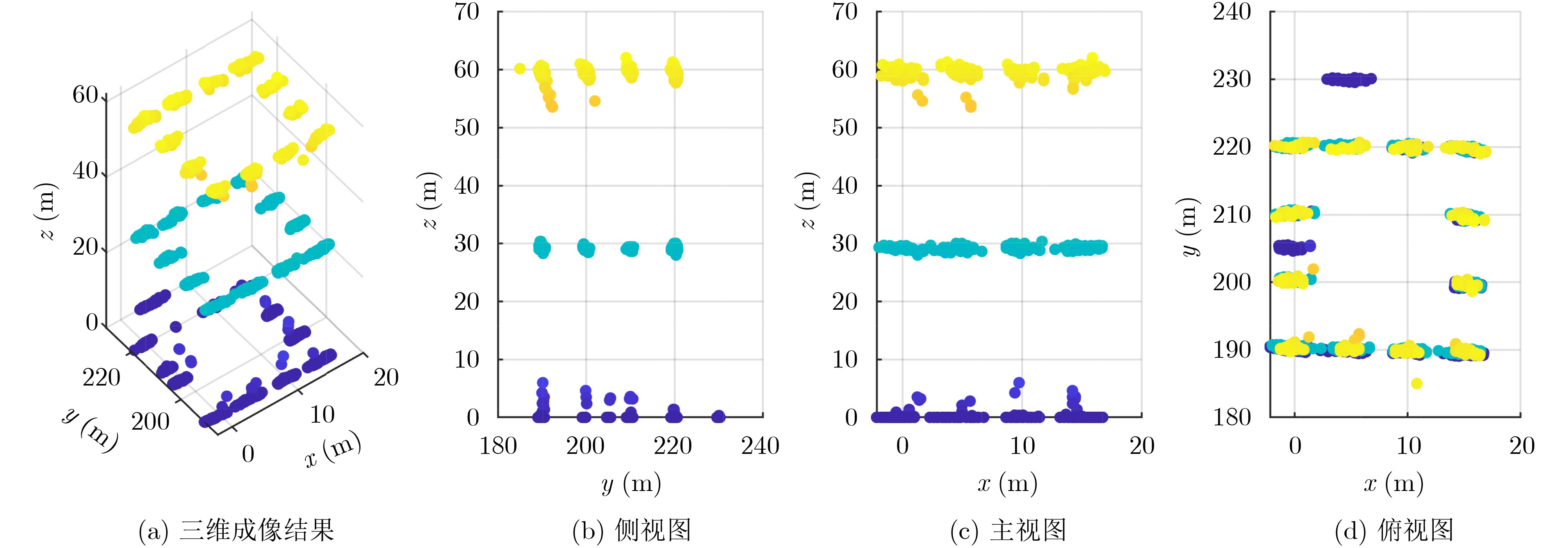
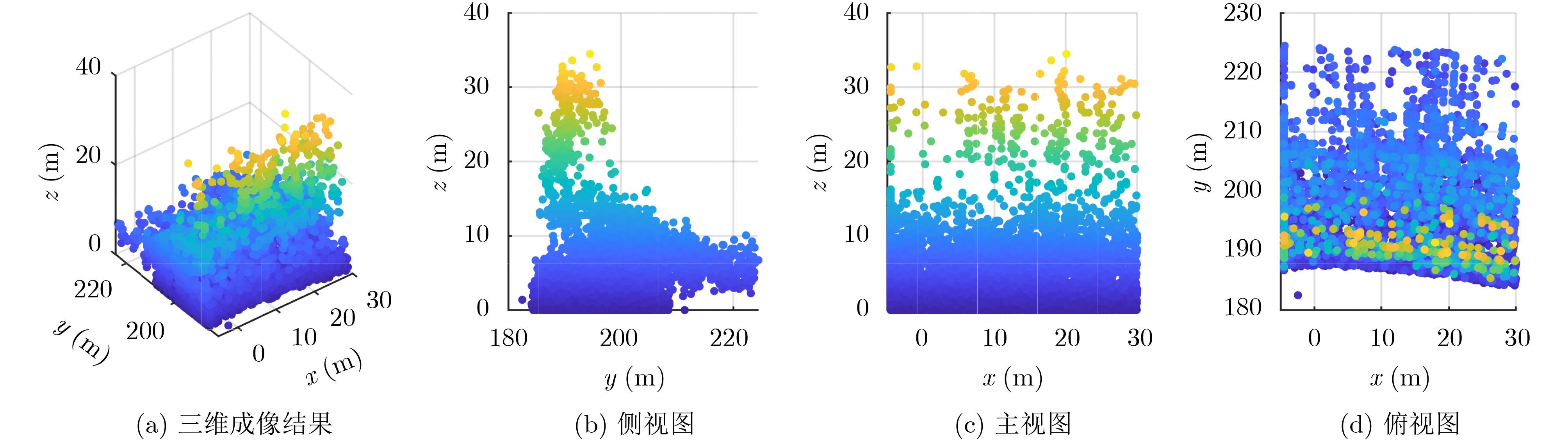
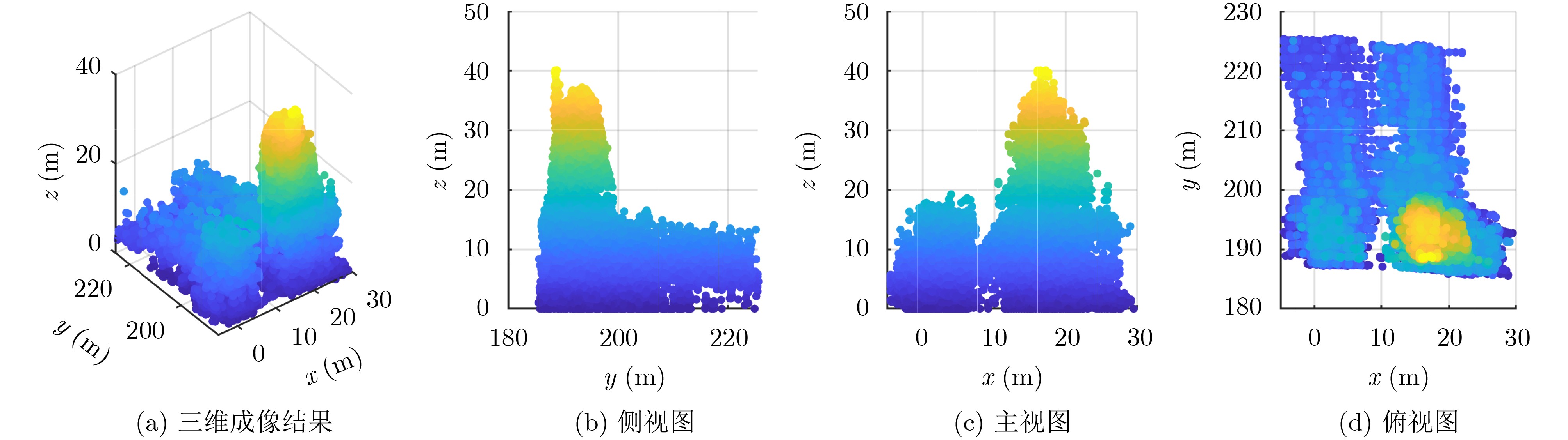
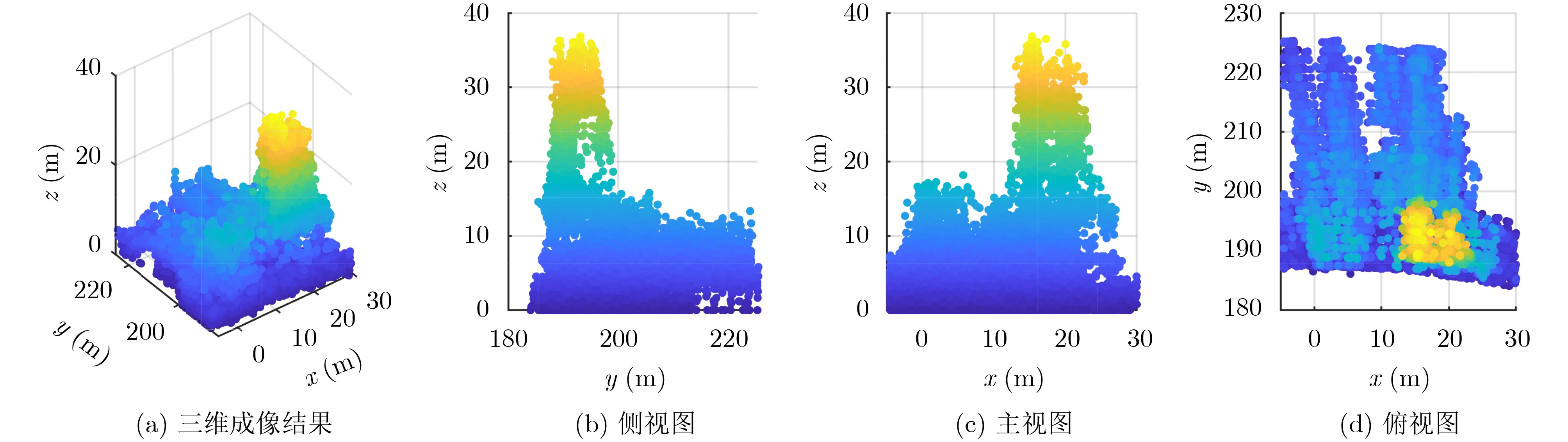
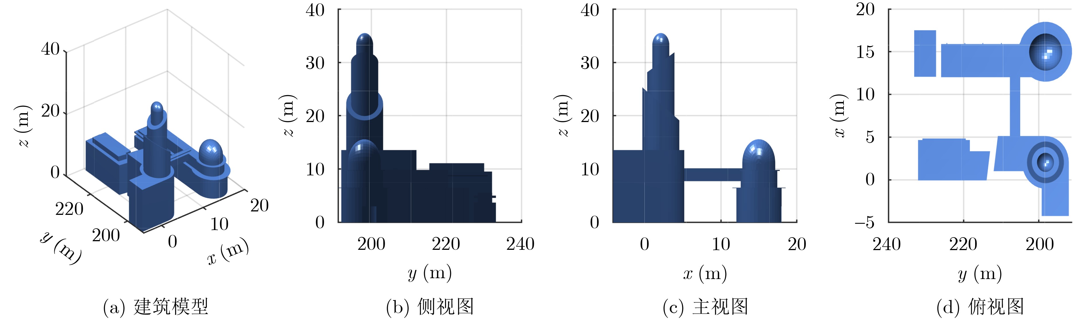
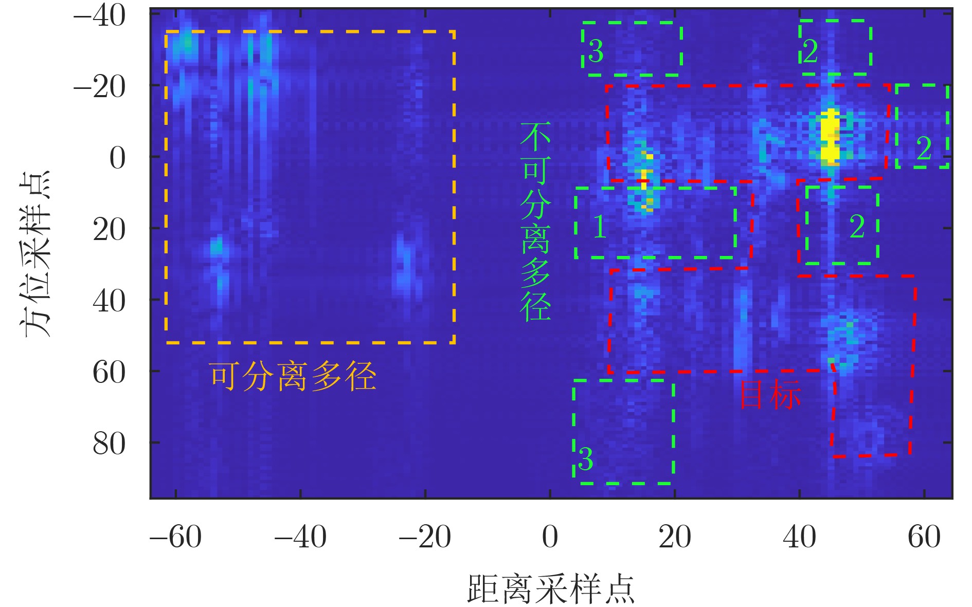
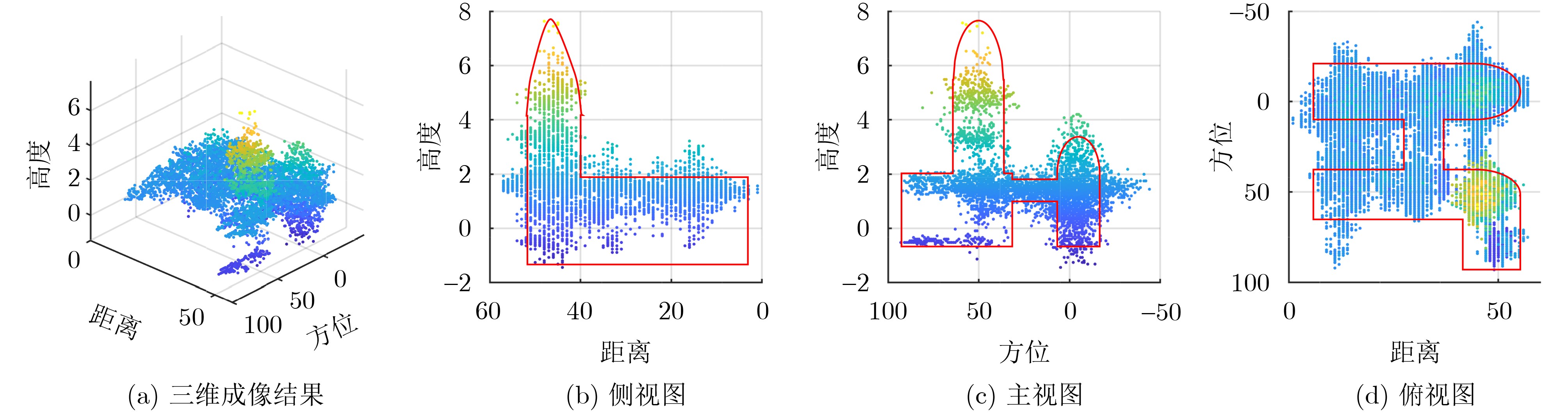
Objective With the rapid development of 6G networks, communication systems are moving toward high bandwidth, low latency, and massive connectivity. In this context, Integrated Sensing and Communication (ISAC) allows wireless signals to transmit information and sense the environment. It provides a basis for more intelligent and efficient 6G services. Environmental reconstruction is a core task in ISAC systems. It aims to recover the true spatial structure of targets and scenes from echo signals. However, practical environmental reconstruction still faces three main challenges. First, dense Base Station (BS) deployment in 6G communication systems places building targets in the near-field region of the imaging system. This causes strong coupling among the range, azimuth, and elevation dimensions in tomographic imaging, resulting in clear deviations between the reconstructed target geometry and its true shape. Second, the positioning error of User Equipment (UE) is much larger than the signal wavelength. Therefore, conventional Synthetic Aperture Radar (SAR) autofocus algorithms become ineffective, and new methods are needed to avoid the effects of positioning errors. Third, conventional Tomographic Synthetic Aperture Radar (TomoSAR) algorithms use a per-channel processing framework, in which Single-Look Complex (SLC) images are generated independently for each channel. When Inverse Synthetic Aperture Radar (ISAR) techniques are used to generate SLC images, data differences among channels cause inconsistent translational phase compensation. These inconsistencies introduce inter-channel phase errors during elevation focusing and produce false targets in the imaging results. Methods This paper first applies the nonparametric translational motion compensation method developed for ISAR imaging to SLC image generation. This strategy avoids the adverse effects caused by UE positioning errors. Existing ISAR studies usually assume that the target satisfies a turntable model. However, the actual SAR imaging geometry differs from this ideal assumption. Therefore, the mathematical mapping between the TomoSAR imaging results and the true spatial coordinates of the target is rederived under the SAR imaging geometry. Based on this mapping, the coordinate reconstruction problem is formulated as a system of nonlinear equations. A coordinate reconstruction method based on Particle Swarm Optimization (PSO) is then proposed to accurately recover the true geometric shape of the target. In addition, to address inconsistent translational phase compensation among channels in conventional per-channel processing frameworks, a joint phase correction TomoSAR framework is designed. A unified phase correction strategy is used to remove inter-channel phase errors, thereby improving elevation focusing and overall imaging quality. Results and Discussions The proposed methods are verified through simulation experiments on complex building targets under ideal and non-ideal trajectory conditions. Chamfer Distance (CD) is used to evaluate coordinate reconstruction accuracy. The CD values under ideal and non-ideal trajectories are 1.62 and 1.68, respectively, which indicates only slight performance degradation under non-ideal conditions. The imaging point cloud under the non-ideal trajectory shows clear point dropout. A comparison of the empirical Cumulative Distribution Function (CDF) curves of distance errors under the two trajectory conditions shows that the overall trends are similar. Clear differences appear only when the distance error exceeds 2 m. This finding indicates that, under the CD metric, the main differences between the imaging results for ideal and non-ideal trajectories are concentrated in point-cloud dropout regions and areas outside the main target. Thus, non-ideal trajectories mainly affect the scattering-intensity distribution. Comparative experiments between the joint phase correction framework and the conventional framework further show that conventional TomoSAR methods produce clear stacking effects at different elevations, with false targets appearing at incorrect elevation levels. This result suggests that independent translational phase compensation in each channel can induce inter-channel phase errors and seriously degrade elevation focusing. By contrast, joint phase correction improves imaging quality. Conclusions The experimental results verify the effectiveness of the proposed methods. By combining ISAR-based nonparametric translational motion compensation with PSO-based coordinate reconstruction, the true geometric shape of the target is successfully recovered. The joint phase correction strategy also eliminates false targets in elevation focusing caused by conventional per-channel processing. It therefore improves elevation focusing capability and overall image quality. -
表 1 通信系统参数和对应的成像参数
参数 数值 资源块数 272 一个资源块含有的子载波数 12 载频 5 GHz 子载波间隔 120 kHz SRS符号的数量 1 带宽 391.68 MHz 采样时间 1.017 ns PRF 200 Hz PRT 40 slots=5 subframes 波长 0.06 m 频域梳状结构 2 循环移位 正常 观测时间 0.5 s 脉宽 8.93 μs  下载: 导出CSV
-
[1] LIU Fan, CUI Yuanhao, MASOUROS C, et al. Integrated sensing and communications: Toward dual-functional wireless networks for 6G and beyond[J]. IEEE Journal on Selected Areas in Communications, 2022, 40(6): 1728–1767. doi: 10.1109/JSAC.2022.3156632. [2] CHENG Xiang, DUAN Dongliang, GAO Shijian, et al. Integrated sensing and communications (ISAC) for vehicular communication networks (VCN)[J]. IEEE Internet of Things Journal, 2022, 9(23): 23441–23451. doi: 10.1109/JIOT.2022.3191386. [3] ZHANG J A, LIU Fan, MASOUROS C, et al. An overview of signal processing techniques for joint communication and radar sensing[J]. IEEE Journal of Selected Topics in Signal Processing, 2021, 15(6): 1295–1315. doi: 10.1109/JSTSP.2021.3113120. [4] WANG Chengxiang, YOU Xiaohu, GAO Xiqi, et al. On the road to 6G: Visions, requirements, key technologies, and testbeds[J]. IEEE Communications Surveys & Tutorials, 2023, 25(2): 905–974. doi: 10.1109/COMST.2023.3249835. [5] GONZÁLEZ-PRELCIC N, TAGLIAFERRI D, KESKIN M F, et al. Six integration avenues for ISAC in 6G and beyond[J]. IEEE Vehicular Technology Magazine, 2025, 20(1): 18–39. doi: 10.1109/MVT.2025.3529403. [6] JIANG Wei, HAN Bin, HABIBI M A, et al. The road towards 6G: A comprehensive survey[J]. IEEE Open Journal of the Communications Society, 2021, 2: 334–366. doi: 10.1109/OJCOMS.2021.3057679. [7] MENG Kaitao, WU Qingqing, MA Shaodan, et al. Throughput maximization for UAV-enabled integrated periodic sensing and communication[J]. IEEE Transactions on Wireless Communications, 2023, 22(1): 671–687. doi: 10.1109/TWC.2022.3197623. [8] BAMLER R. A comparison of range-Doppler and wavenumber domain SAR focusing algorithms[J]. IEEE Transactions on Geoscience and Remote Sensing, 1992, 30(4): 706–713. doi: 10.1109/36.158864. [9] DESAI M D and JENKINS W K. Convolution backprojection image reconstruction for spotlight mode synthetic aperture radar[J]. IEEE Transactions on Image Processing, 1992, 1(4): 505–517. doi: 10.1109/83.199920. [10] RANEY R K, RUNGE H, BAMLER R, et al. Precision SAR processing using chirp scaling[J]. IEEE Transactions on Geoscience and Remote Sensing, 1994, 32(4): 786–799. doi: 10.1109/36.298008. [11] JIANG Changhui, CHEN Yuwei, CHEN Chen, et al. Smartphone PDR/GNSS integration via factor graph optimization for pedestrian navigation[J]. IEEE Transactions on Instrumentation and Measurement, 2022, 71: 8504112. doi: 10.1109/TIM.2022.3186082. [12] SAYED A H, TARIGHAT A, and KHAJEHNOURI N. Network-based wireless location: Challenges faced in developing techniques for accurate wireless location information[J]. IEEE Signal Processing Magazine, 2005, 22(4): 24–40. doi: 10.1109/MSP.2005.1458275. [13] YIN Lu, NI Qiang, and DENG Zhongliang. A GNSS/5G integrated positioning methodology in D2D communication networks[J]. IEEE Journal on Selected Areas in Communications, 2018, 36(2): 351–362. doi: 10.1109/JSAC.2018.2804223. [14] CALLOWAY T M and DONOHOE G W. Subaperture autofocus for synthetic aperture radar[J]. IEEE Transactions on Aerospace and Electronic Systems, 1994, 30(2): 617–621. doi: 10.1109/7.272285. [15] EICHEL P H and JAKOWATZ C V. Phase-gradient algorithm as an optimal estimator of the phase derivative[J]. Optics Letters, 1989, 14(20): 1101–1103. doi: 10.1364/OL.14.001101. [16] WAHL D E, EICHEL P H, GHIGLIA D C, et al. Phase gradient autofocus-a robust tool for high resolution SAR phase correction[J]. IEEE Transactions on Aerospace and Electronic Systems, 1994, 30(3): 827–835. doi: 10.1109/7.303752. [17] ASH J N. An autofocus method for backprojection imagery in synthetic aperture radar[J]. IEEE Geoscience and Remote Sensing Letters, 2012, 9(1): 104–108. doi: 10.1109/LGRS.2011.2161456. [18] HU Kebin, ZHANG Xiaoling, HE Shufeng, et al. A less-memory and high-efficiency autofocus back projection algorithm for SAR imaging[J]. IEEE Geoscience and Remote Sensing Letters, 2015, 12(4): 890–894. doi: 10.1109/LGRS.2014.2365612. [19] ZHANG Tao, LIAO Guisheng, LI Yachao, et al. An improved time-domain autofocus method based on 3-D motion errors estimation[J]. IEEE Transactions on Geoscience and Remote Sensing, 2022, 60: 5223816. doi: 10.1109/TGRS.2021.3137422. [20] 李浩林, 陈露露, 张磊, 等. 快速分解后向投影SAR成像的自聚焦算法研究[J]. 电子与信息学报, 2014, 36(4): 938–945. doi: 10.3724/SP.J.1146.2013.00011.LI Haolin, CHEN Lulu, ZHANG Lei, et al. Study of autofocus method for SAR imagery created by fast factorized backprojection[J]. Journal of Electronics & Information Technology, 2014, 36(4): 938–945. doi: 10.3724/SP.J.1146.2013.00011. [21] ZHANG Tao, LIAO Guisheng, LI Yachao, et al. A two-stage time-domain autofocus method based on generalized sharpness metrics and AFBP[J]. IEEE Transactions on Geoscience and Remote Sensing, 2022, 60: 5205413. doi: 10.1109/TGRS.2021.3068789. [22] LOU Yishan, LIN Hao, LI Ning, et al. A prior 2-D autofocus algorithm with ground cartesian BP imaging for curved trajectory SAR[J]. IEEE Journal of Selected Topics in Applied Earth Observations and Remote Sensing, 2024, 17: 2422–2436. doi: 10.1109/JSTARS.2023.3346942. [23] LIU Yanqi, FAN Jixia, TAO Manyi, et al. Modified time-domain backprojection algorithm for SAR frequency-domain autofocus[J]. IEEE Transactions on Geoscience and Remote Sensing, 2025, 63: 5208116. doi: 10.1109/TGRS.2025.3547912. [24] AUSHERMAN D A, KOZMA A, WALKER J L, et al. Developments in radar imaging[J]. IEEE Transactions on Aerospace and Electronic Systems, 1984, AES-20(4): 363–400. doi: 10.1109/TAES.1984.4502060. [25] 庞怡杰, 王国林, 许荣庆. 一种改进的ISAR运动补偿方法[J]. 系统工程与电子技术, 1998(6): 39–43.PANG Yijie, WANG Guolin, and XU Rongqing. An improved method of motion compensation for ISAR[J]. Systems Engineering and Electronics, 1998(6): 39–43. [26] 朱兆达, 邱晓晖, 佘志舜. 用改进的多普勒中心跟踪法进行ISAR运动补偿[J]. 电子学报, 1997, 25(3): 65–69.ZHU Zhaoda, QIU Xiaohui, and SHE Zhishun. ISAR motion compensation using modified Doppler centroid tracking method[J]. Acta Electronica Sinica, 1997, 25(3): 65–69. [27] CAI T T and WANG Lie. Orthogonal matching pursuit for sparse signal recovery with noise[J]. IEEE Transactions on Information Theory, 2011, 57(7): 4680–4688. doi: 10.1109/TIT.2011.2146090. [28] PATI Y C, REZAIIFAR R, and KRISHNAPRASAD P S. Orthogonal matching pursuit: Recursive function approximation with applications to wavelet decomposition[C]. Proceedings of 27th Asilomar Conference on Signals, Systems and Computers, Pacific Grove, United States, 1993: 40–44. doi: 10.1109/ACSSC.1993.342465. [29] YIN Lannuo and WANG Yong. Tomographic bistatic 3-D imaging and coordinate reconstruction method based on uplink communication process[J]. IEEE Transactions on Geoscience and Remote Sensing, 2025, 63: 5208316. doi: 10.1109/TGRS.2025.3556011. -

 下载:
下载:


图(22) / 表(2)
计量
- 文章访问数: 274
- HTML全文浏览量: 176
- PDF下载量: 27
- 被引次数: 0
