

A Moving Target Detection Method for GEO SAR Image in Maritime Areas
-
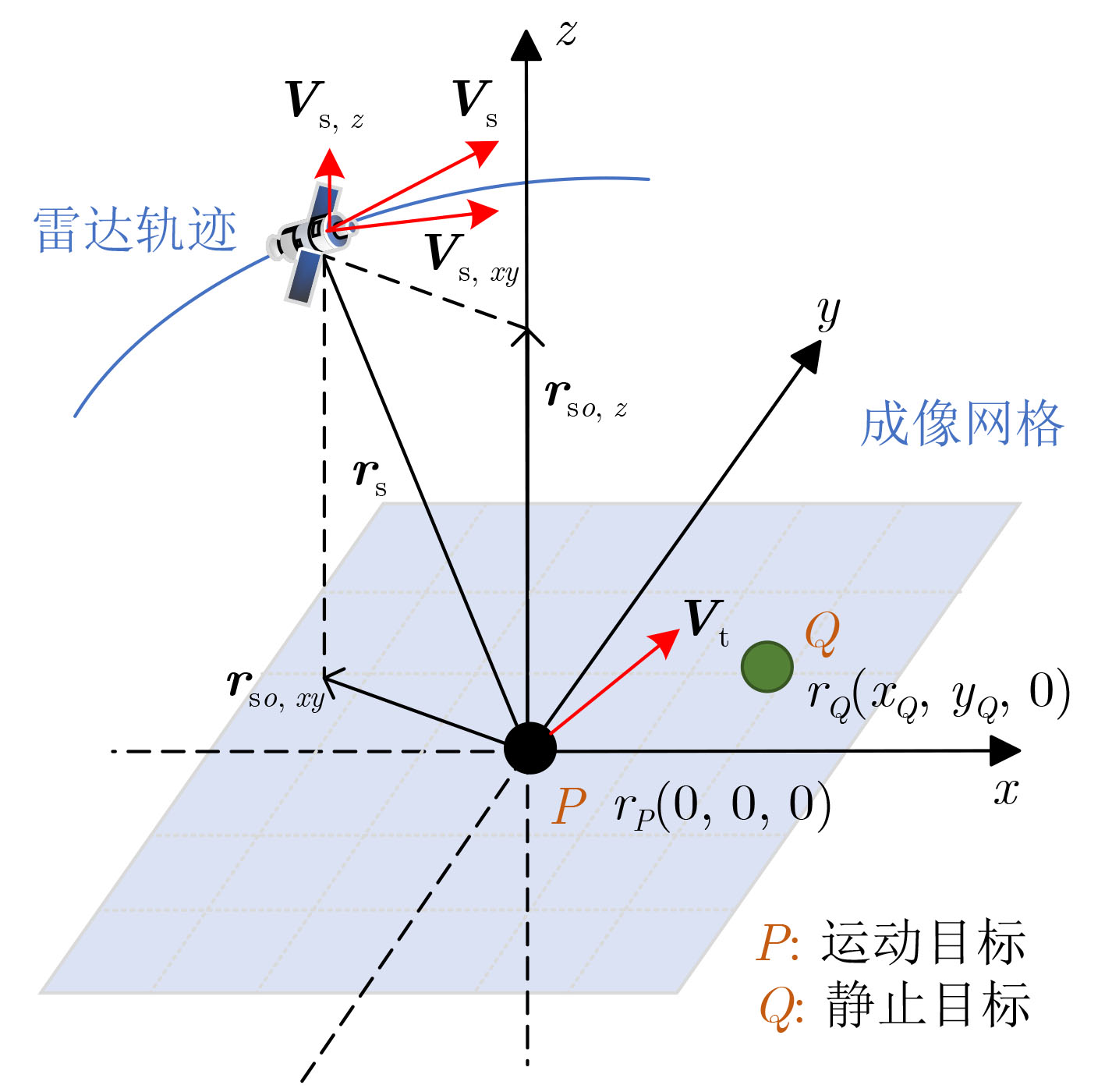
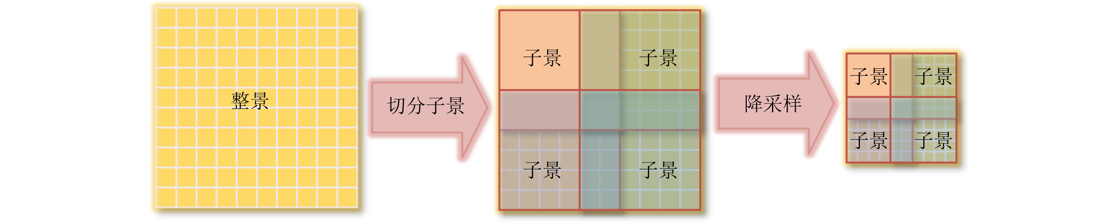
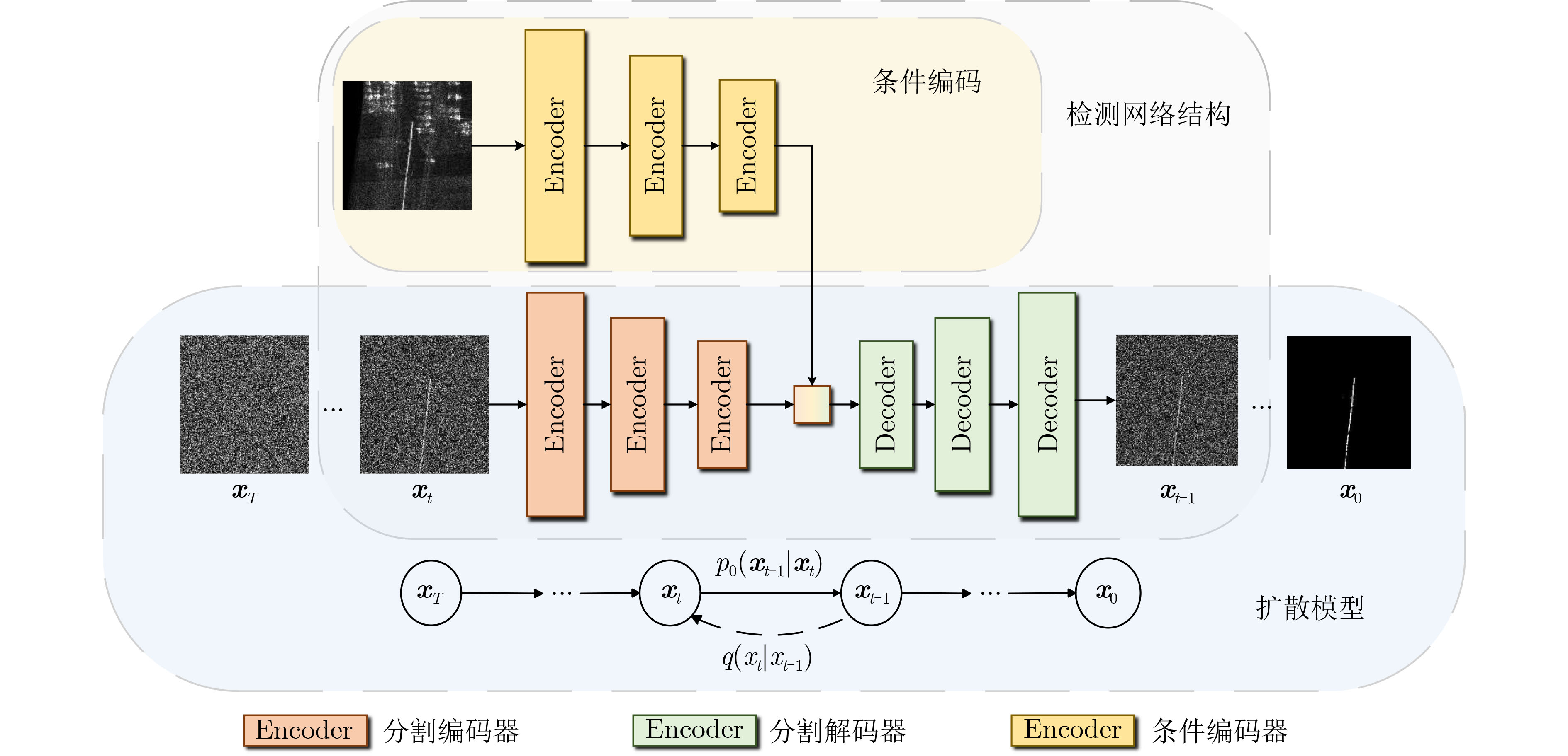
摘要: 地球同步轨道合成孔径雷达(GEO SAR)具有宽覆盖、高重访、近凝视等成像优势,具备对广域海场景运动目标的长时间监测能力。然而,运动目标在图像中严重偏移且剧烈散焦,对GEO SAR海上区域运动目标检测造成困难,主要包括2个关键问题:(1) 超长的合成孔径时间、超慢的星地相对速度会导致运动目标严重散焦;(2) 超大幅宽图像、陆海目标混淆增加了运动目标检测难度。为了解决这些问题,该文分析了GEO SAR动目标的位置偏移以及相位误差等影响,根据影响特点提出一种面向GEO SAR图像的海面运动目标检测方法。该检测方法通过图像预处理步骤对整幅图像进行分块处理和降采样滤波,以提高计算效率、增强信杂比,使运动目标的特征更加突出、在复杂背景中更加显著。该检测方法通过条件扩散检测网络,将预处理后的GEO SAR图像作为条件编码输入,约束检测结果的生成,得到运动目标分割掩码;通过设计密集交互模块,实现分割图与原始数据在潜在空间中的多尺度特征耦合。实验结果表明,所提出的预处理能够有效减少数据处理的计算复杂度,同时提高图像的信杂比。基于仿真数据,在广域海场景中,所提的动目标检测方法能够准确检测出GEO SAR图像中海面区域的动目标。
-
关键词:
- 地球同步轨道合成孔径雷达 /
- 运动目标检测 /
- 深度学习 /
- 扩散模型
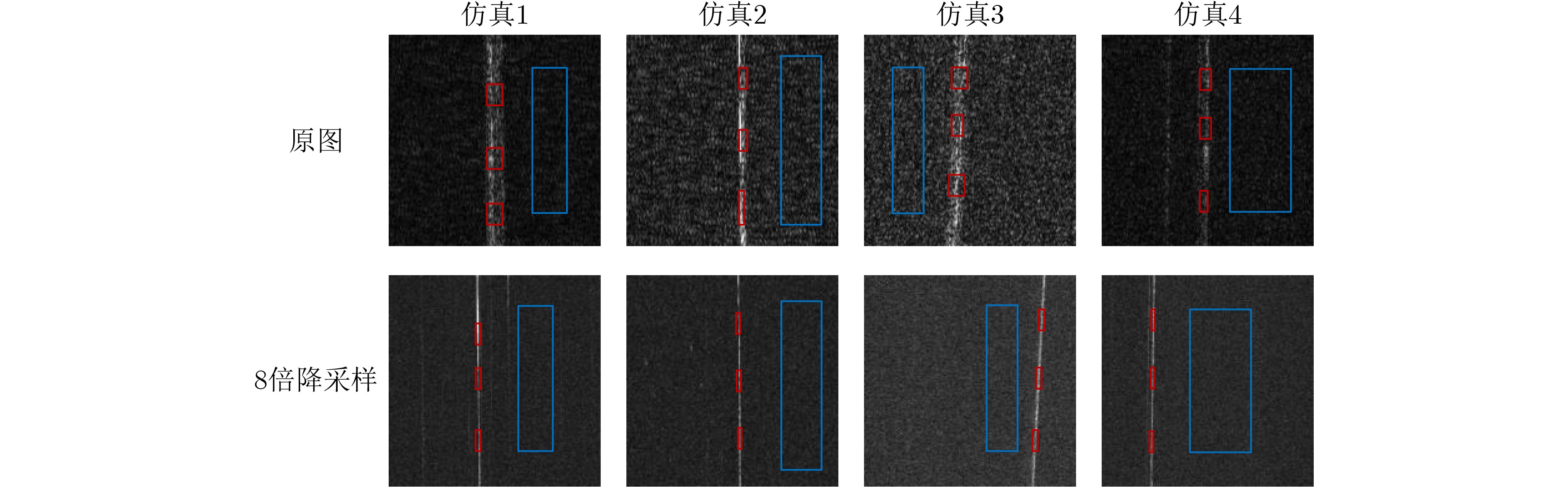
Abstract:Objective Geosynchronous Synthetic Aperture Radar (GEO SAR) provides wide-area coverage and rapid revisit, supporting near real-time observation of large maritime regions. However, detecting moving targets in GEO SAR images remains challenging due to severe geometric shifts and defocusing effects induced by target motion. These issues are further compounded when deep learning-based detection algorithms are applied. Specifically, the extended synthetic aperture time of GEO SAR leads to significant motion-induced defocusing, degrading the structural clarity of moving targets. Moreover, the wide swath of GEO SAR results in sparsely distributed moving targets, substantially increasing computational demands. The long integration time also renders GEO SAR imagery more sensitive to sea clutter, which elevates false alarm rates and obscures target backscattering signatures, thereby compromising target contour visibility. To address these challenges, this study analyzes the displacement and phase errors introduced by moving targets under the non-linear squint-angle imaging geometry of GEO SAR. Based on this analysis, a diffusion model-based method is proposed to detect maritime moving targets in GEO SAR imagery. Methods To address the aforementioned challenges, this study analyzes azimuth displacement and phase errors induced by target motion under the non-planar squint-angle imaging geometry of GEO SAR. Based on this analysis, a diffusion-based approach is proposed for detecting maritime moving targets in GEO SAR imagery. The method comprises two primary components: a preprocessing stage and a conditional diffusion detection network. In the preprocessing stage, the full-scene image is divided into smaller sub-scenes to mitigate the difficulty of directly processing ultra-wide-swath GEO SAR data. These sub-scenes are subsequently downsampled to dimensions compatible with network input, which enhances the signal-to-noise ratio and strengthens the representation of motion-related features. In the detection stage, a conditional diffusion detection network tailored for GEO SAR is developed. This network accepts the preprocessed image as conditional input to guide the generation of detection results, thereby improving accuracy. To further refine performance, a dense interaction module is introduced to facilitate multi-scale feature fusion between the segmentation mask and original data in the latent space, enabling precise segmentation of moving targets. Results and Discussions To evaluate the effectiveness of the proposed detection method, the imaging characteristics of sea clutter and moving targets under long synthetic aperture time are simulated. The sea surface is modeled using the Jonswap spectrum, and clutter is generated via a backscattering coefficient model, resulting in simulated imagery of sea clutter and moving targets under extended integration time ( Fig. 5 ). A quantitative analysis is performed to examine the effect of downsampling on detection performance by calculating the Signal-to-Clutter Ratio (SCR), as summarized inTable 4 . The results show that 8× downsampling improves the SCR by 11.3 dB. After preprocessing, the downsampled sub-scenes are fed into the detection network to produce moving target detection results (Fig. 6 ). Compared to other methods, the proposed approach yields improvements of 1.1%, 2.2%, and 0.9% in Intersection over Union (IoU), Accuracy, and F1-score, respectively.Conclusions To address the challenges of detecting moving maritime targets in GEO SAR images—such as ultra-long synthetic aperture duration, extremely wide swath, and interference from sea clutter—this study first analyzes azimuth displacement and phase errors introduced by target motion under the non-linear squint-angle imaging geometry of GEO SAR. A detection method is then proposed, comprising two key components: preprocessing and a conditional diffusion detection network. During preprocessing, the full-scene image is divided into multiple sub-scenes to facilitate processing of ultra-wide-swath GEO SAR data. These sub-scenes are downsampled to dimensions compatible with the detection network, improving the SCR, enhancing motion features, and suppressing clutter. In the detection stage, a conditional diffusion detection network customized for GEO SAR imagery is employed. This network uses the preprocessed sub-scenes as conditional input to guide the generation of detection results, enhancing accuracy. A dense interaction module is further incorporated to enable multi-scale feature coupling between the segmentation mask and the original data in the latent space, achieving pixel-level segmentation of moving targets. Simulation experiments confirm the method’s effectiveness in detecting moving maritime targets under complex oceanic conditions. Although initial progress has been achieved, further work is required to improve parameter extraction and optimize network performance. Future efforts will focus on refining detection models for more comprehensive analysis of moving targets in GEO SAR imagery. -
表 1 GEO SAR仿真参数
参数 值 轨道参数 轨道半长轴(km) 42164 轨道偏心率(°) 0 轨道倾角(–) 16 场景参数 目标经度(°E) 122.2 目标纬度(°N) 28.0  下载: 导出CSV
表 2 动目标位置偏移仿真结果
速度(km/h) 位置偏移(km) 正东 正北 正西 正南 东北 西北 东南 西南 15 $ {r_{Q1}} $ –168.6 –118.8 168.6 118.8 –203.2 35.1 –35.1 203.2 $ {r_{Q2}} $ 113.2 79.6 –111.4 –78.7 136.7 –23.3 23.4 –134.2 30 $ {r_{Q1}} $ –337.2 –237.7 337.2 237.7 –406.5 70.3 –70.3 406.5 $ {r_{Q2}} $ 228.18 160.1 –221.2 –156.7 276.0 –46.6 47.0 –265.9 45 $ {r_{Q1}} $ –505.7 –356.6 505.7 356.6 –609.8 105.4 –105.4 609.8 $ {r_{Q2}} $ 344.9 241.5 –329.3 –233.8 417.8 –69.9 70.6 –395.1 60 $ {r_{Q1}} $ –674.3 –475.5 674.3 475.5 –813.1 140.6 –140.6 813.1 $ {r_{Q2}} $ 463.5 328.8 –435.7 –310.0 562.4 –93.0 94.3 –522.0
下载: 导出CSV
表 3 动目标二次相位误差仿真结果
目标运动速度
(km/h)合成孔径时间
(min)二次相位误差(°) 东 北 西 南 东北 西北 东南 西南 15 10 6.8 -303.6 -9.1 301.4 -209.3 -220.6 218.4 207.1 20 27.5 - 1214.5 -36.3 1205.7 -837.4 -882.6 873.8 828.6 30 61.9 - 2732.5 -81.7 2712.8 - 1884.3 - 1985.9 1966.1 1864.5 30 10 11.5 -609.4 -20.3 600.6 -420.9 -443.5 434.7 412.1 20 46.3 - 2437.7 -81.4 2402.6 - 1683.7 - 1774.0 1738.9 1648.6 30 104.2 - 5484.8 -183.2 5405.8 - 3788.3 - 3991.5 3912.5 3709.3 45 10 14.1 -917.4 -33.8 897.6 -634.6 -668.5 648.7 614.9 20 56.3 - 3669.7 -135.3 3590.7 - 2538.7 - 2674.2 2595.2 2459.7 30 126.7 - 8256.8 -304.4 8079.0 - 5712.0 - 6016.9 5839.2 5534.3 60 10 14.3 - 1227.6 -49.4 1192.5 -850.6 -895.7 860.6 815.4 20 57.5 - 4910.5 -197.9 4770.0 - 3402.5 - 3583.2 3442.7 3262.0 30 129.4 - 1104.9 -445.4 1073.3 - 7655.5 - 8062.1 7746.0 7339.5
下载: 导出CSV
表 4 信杂比计算结果
SCR (dB) 仿真1 仿真2 仿真3 仿真4 平均 原图 20.9378 18.9518 13.8055 8.9381 15.6583 8倍降采样 31.6631 34.5891 22.2958 19.2201 26.9420
下载: 导出CSV
表 5 所提检测方法与其他方法对比结果(%)
方法 IoU Acc F1 FCN 53.7 85.8 69.9 Deeplab 58.4 88.4 73.7 PSPNet 61.6 88.6 76.2 本文 62.7 90.8 77.1
下载: 导出CSV
-
[1] 林晨晨, 李光廷, 孙娟, 等. 陆探四号01星微波通道在轨自主相位补偿方法[J]. 空间电子技术, 2024, 21(2): 17–22. doi: 10.3969/j.issn.1674-7135.2024.02.002.LIN Chenchen, LI Guangting, SUN Juan, et al. On-orbit autonomously phase compensation method for microwave channels of LT-4 (01)[J]. Space Electronic Technology, 2024, 21(2): 17–22. doi: 10.3969/j.issn.1674-7135.2024.02.002. [2] BRUNO D, HOBBS S E, and OTTAVIANELLI G. Geosynchronous synthetic aperture radar: Concept design, properties and possible applications[J]. Acta Astronautica, 2006, 59(1/5): 149–156. doi: 10.1016/j.actaastro.2006.02.005. [3] 聂娟, 邓磊, 郝向磊, 等. 高分四号卫星在干旱遥感监测中的应用[J]. 遥感学报, 2018, 22(3): 400–407. doi: 10.11834/jrs.20187067.NIE Juan, DENG Lei, HAO Xianglei, et al. Application of GF-4 satellite in drought remote sensing monitoring: A case study of Southeastern Inner Mongolia[J]. Journal of Remote Sensing, 2018, 22(3): 400–407. doi: 10.11834/jrs.20187067. [4] 胡哲颖, 黄丽佳, 胡文龙, 等. 高轨SAR非平直几何动目标成像影响建模[J]. 雷达科学与技术, 2018, 16(5): 496–504. doi: 10.3969/j.issn.1672-2337.2018.05.006.HU Zheying, HUANG Lijia, HU Wenlong, et al. Modeling and analysis of target motion influence on GEO SAR based on non-straight squint imaging geometry[J]. Radar Science and Technology, 2018, 16(5): 496–504. doi: 10.3969/j.issn.1672-2337.2018.05.006. [5] WANG Chao, GUO Baolong, SONG Jiawei, et al. A novel CFAR-based ship detection method using range-compressed data for spaceborne SAR system[J]. IEEE Transactions on Geoscience and Remote Sensing, 2024, 62: 5215515. doi: 10.1109/TGRS.2024.3419893. [6] ZHOU Wei, XIE Junhao, LI Gaopeng, et al. Robust CFAR detector with weighted amplitude iteration in nonhomogeneous sea clutter[J]. IEEE Transactions on Aerospace and Electronic Systems, 2017, 53(3): 1520–1535. doi: 10.1109/TAES.2017.2671798. [7] SHI Sainan and SHUI Penglang. Sea-surface floating small target detection by one-class classifier in time-frequency feature space[J]. IEEE Transactions on Geoscience and Remote Sensing, 2018, 56(11): 6395–6411. doi: 10.1109/TGRS.2018.2838260. [8] SHUI Penglang, LI Dongchen, and XU Shuwen. Tri-feature-based detection of floating small targets in sea clutter[J]. IEEE Transactions on Aerospace and Electronic Systems, 2014, 50(2): 1416–1430. doi: 10.1109/TAES.2014.120657. [9] ZHAO Chunhui, LIU Haodong, WANG Lu, et al. SAR image wake detection based on pseudo-Siamese structure and multidomain feature fusion[J]. IEEE Geoscience and Remote Sensing Letters, 2024, 21: 4015605. doi: 10.1109/LGRS.2024.3436855. [10] GUAN Yanan, XU Huaping, and LI Chunsheng. A method of ship wake detection in SAR images based on reconstruction features and anomaly detector[C]. 2023 IEEE International Geoscience and Remote Sensing Symposium, Pasadena, USA, 2023. doi: 10.1109/IGARSS52108.2023.10281571. [11] DENG Jie, WANG Wei, ZHANG Huiqiang, et al. PolSAR ship detection based on superpixel-level contrast enhancement[J]. IEEE Geoscience and Remote Sensing Letters, 2024, 21: 4008805. doi: 10.1109/LGRS.2024.3388989. [12] ZHANG Tao, QUAN Sinong, YANG Zhen, et al. A two-stage method for ship detection using PolSAR image[J]. IEEE Transactions on Geoscience and Remote Sensing, 2022, 60: 52369818. doi: 10.1109/TGRS.2022.3216532. [13] LI Jianwei, CHEN Jie, CHENG Pu, et al. A survey on deep-learning-based real-time SAR ship detection[J]. IEEE Journal of Selected Topics in Applied Earth Observations and Remote Sensing, 2023, 16: 3218–3247. doi: 10.1109/JSTARS.2023.3244616. [14] LI Dong, LIANG Quanhuan, LIU Hongqing, et al. A novel multidimensional domain deep learning network for SAR ship detection[J]. IEEE Transactions on Geoscience and Remote Sensing, 2022, 60: 5203213. doi: 10.1109/TGRS.2021.3062038. [15] ZHU Xiaoxiang, MONTAZERI S, ALI M, et al. Deep Learning Meets SAR: Concepts, models, pitfalls, and perspectives[J]. IEEE Geoscience and Remote Sensing Magazine, 2021, 9(4): 143–172. doi: 10.1109/MGRS.2020.3046356. [16] GRECO M, STINCO P, and GINI F. Identification and analysis of sea radar clutter spikes[J]. IET Radar, Sonar & Navigation, 2010, 4(2): 239–250. doi: 10.1049/iet-rsn.2009.0088. [17] GREGERS-HANSEN V and MITAL R. An improved empirical model for radar sea clutter reflectivity[J]. IEEE Transactions on Aerospace and Electronic Systems, 2012, 48(4): 3512–3524. doi: 10.1109/TAES.2012.6324732. [18] HO J, JAIN A, and ABBEEL P. Denoising diffusion probabilistic models[C]. The 34th International Conference on Neural Information Processing Systems, Vancouver, Canada, 2020: 574. [19] YU Shuang, XIAO Di, FROST S, et al. Robust optic disc and cup segmentation with deep learning for glaucoma detection[J]. Computerized Medical Imaging and Graphics, 2019, 74: 61–71. doi: 10.1016/j.compmedimag.2019.02.005. [20] NICHOL A Q and DHARIWAL P. Improved denoising diffusion probabilistic models[C/OL]. The 38th International Conference on Machine Learning, 2021: 8162–8171. [21] CHEN Jianlai, SUN Guangcai, XING Mengdao, et al. A two-dimensional beam-steering method to simultaneously consider Doppler centroid and ground observation in GEOSAR[J]. IEEE Journal of Selected Topics in Applied Earth Observations and Remote Sensing, 2017, 10(1): 161–167. doi: 10.1109/JSTARS.2016.2544349. -

 下载:
下载:


图(6) / 表(5)
计量
- 文章访问数: 1028
- HTML全文浏览量: 567
- PDF下载量: 120
- 被引次数: 0
