Processing Algorithm Based on Fast Back-projection for Imaging of Ultra-WideBand Ice-sounding Data
-
摘要: 该文提出一种新的冰雷达成像算法,该算法可以在获得高分辨率冰下剖面图的同时,拥有较高的处理效率。该算法是一种基于快速后向投影的超宽带(UWB)冰雷达成像方法,其修正了多层媒质情况下的雷达与目标之间的距离,以及因多层媒质造成的距离徙动几何变化。该文分析了算法的原理,给出了算法实现的具体步骤,并将其应用于点目标仿真和航空冰雷达数据实验,验证了算法在冰下成像中的有效性。此外,将该方法与现有常用冰雷达算法的成像结果在方位向杂波抑制能力、计算时间和方位向分辨率3个方面进行了对比,证明该算法能够在不降低方位向杂波抑制能力和方位向分辨率的前提下,有效提高计算效率。Abstract: A new algorithm for imaging of ice-sounding radar is proposed, which can obtain high-resolution subglacial profiles with high processing efficiency. This algorithm, which is a processing algorithm based on fast back-projection for imaging of Ultra-WideBand(UWB) ice-sounding radar, can correct the distance between radar and targets in multilayer media and the geometric variation of range migration caused by multilayer media. The theory of the algorithm is analyzed and the implementation steps of the algorithm are given in this paper, and the algorithm is applied to point targets simulation and ice-sounding data experiment, which verifies the effectiveness of the algorithm in imaging of ice-sounding data. Furthermore, the results of the proposed algorithm with those of the existing ice-sounding radar processing algorithms are compared in three aspect of azimuth clutter suppression ability, computing time and azimuth resolution ability, which verifies this algorithm can effectively improve the computational efficiency without reducing the azimuth clutter suppression ability and azimuth resolution.
-
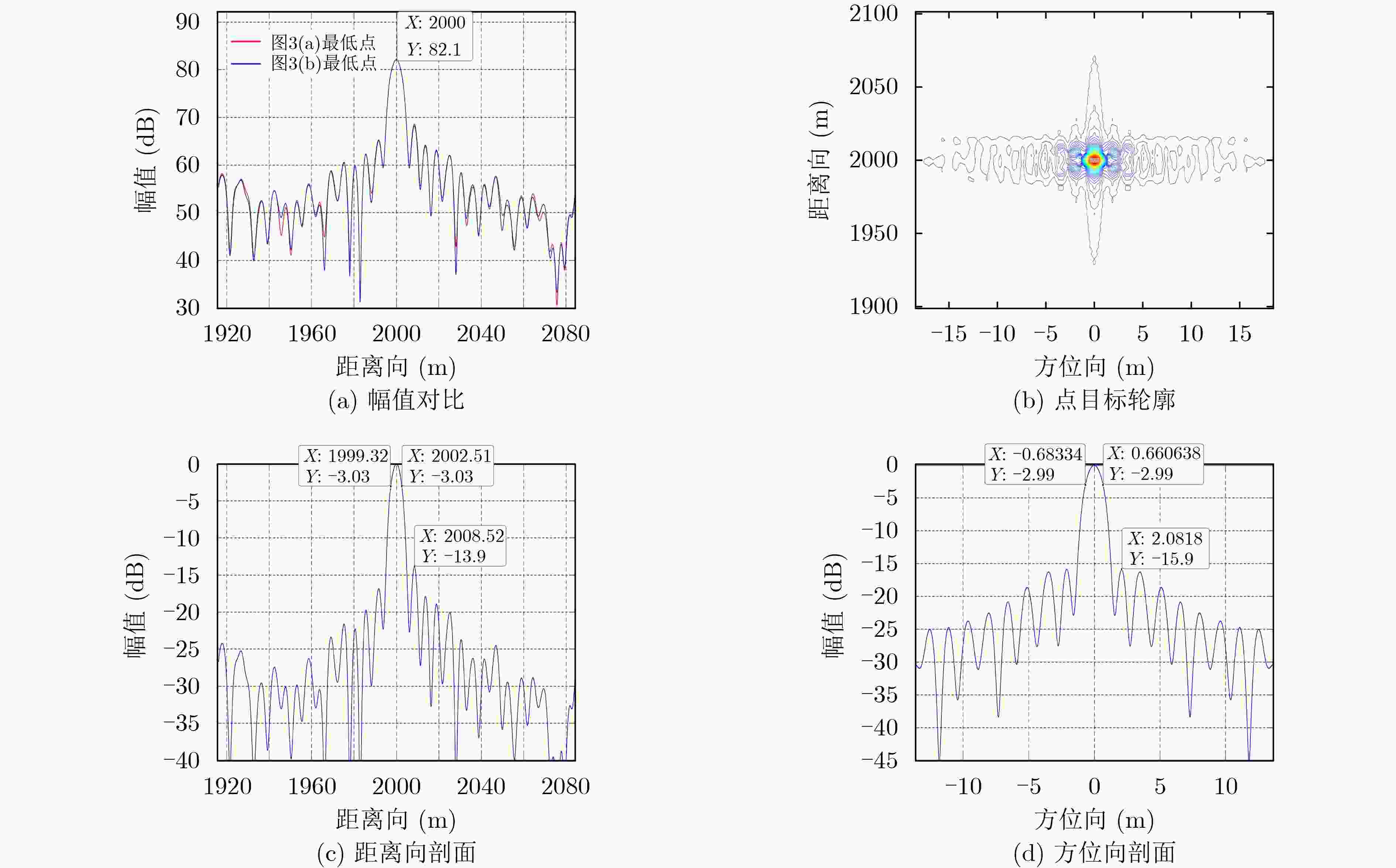
表 1 仿真参数
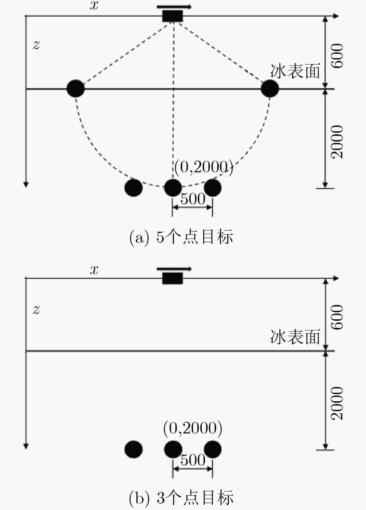
参数名称 参数值 雷达类型 线性调频脉冲 射频载波频率 60 MHz 发射脉冲持续时间 1 μs 信号带宽 15 MHz 距离向采样率 50 MHz 脉冲重复频率 195 Hz 雷达平台速度 90 m/s 雷达平台高度 600 m 合成孔径长度 3985 m 表 2 点目标处理测量结果
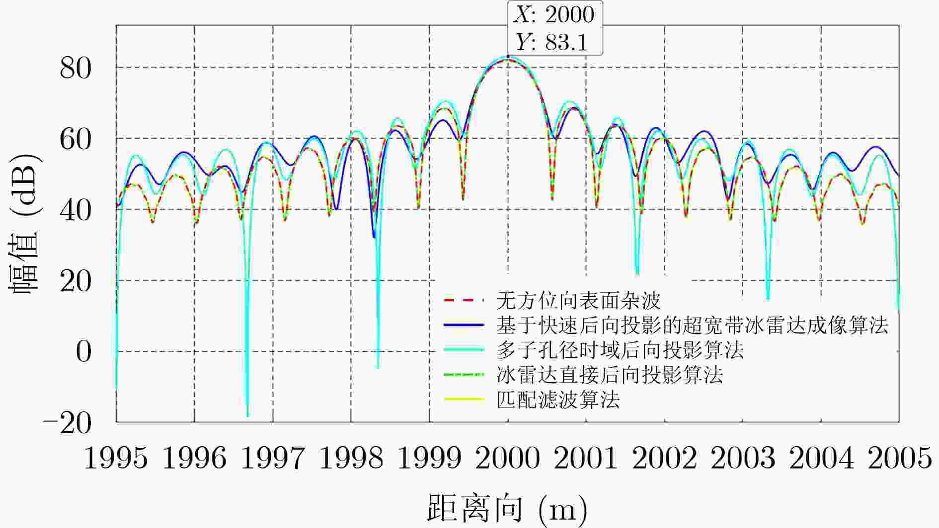
方法名称 方位向分辨率(3dB宽度)(m) 方位向杂波抑制能力 计算时间(s) 基于快速后向投影的超宽带冰雷达成像算法 1.34 冰面点目标受到抑制 2195.04 多子孔径时域后向投影算法 84.96 冰面点目标受到抑制 2080.20 冰雷达直接后向投影算法 1.22 冰面点目标受到抑制 12464.34 匹配滤波算法 1.22 冰面点目标受到抑制 1827.86 -
[1] CUI Xiangbin, GREENBAUM J S, BEEM L H, et al. The first fixed-wing aircraft for Chinese Antarctic expeditions: Airframe, modifications, scientific instrumentation and applications[J]. Journal of Environmental and Engineering Geophysics, 2018, 23(1): 1–13. doi: 10.2113/JEEG23.1.1 [2] CAI Yiheng, LIU Dan, XIE Jin, et al. Attention multi-scale network for automatic layer extraction of ice radar topological sequences[J]. Remote Sensing, 2021, 13(12): 2425. doi: 10.3390/rs13122425 [3] CAI Yiheng, HU Shaobin, LANG Shinan, et al. End-to-end classification network for ice sheet subsurface targets in radar imagery[J]. Applied Sciences, 2020, 10(7): 2501. doi: 10.3390/app10072501 [4] LANG Shinan, CUI Xiangbin, ZHAO Yukai, et al. A novel range processing method of surface-based FMCW ice-sounding radar for accurately mapping the internal reflecting horizons in Antarctica[J]. IEEE Journal of Selected Topics in Applied Earth Observations and Remote Sensing, 2020, 13: 3633–3643. doi: 10.1109/JSTARS.2020.3004357 [5] 杨望笑, 窦银科, 稂时楠, 等. 基于改进剥层法的南极冰盖密度反演算法[J]. 电子与信息学报, 2022, 44(4): 1311–1317. doi: 10.11999/JEIT210410YANG Wangxiao, DOU Yinke, LANG Shinan, et al. Antarctic ice sheet density inversion algorithm based on improved layer stripping method[J]. Journal of Electronics &Information Technology, 2022, 44(4): 1311–1317. doi: 10.11999/JEIT210410 [6] ZHAO Bo, ZHANG Yueyi, LANG Shinan, et al. Shallow-layers-detection ice sounding radar for mapping of polar ice sheets[J]. IEEE Transactions on Geoscience and Remote Sensing, 2021, 60: 4301010. doi: 10.1109/TGRS.2021.3074186 [7] 崔祥斌, 孙波, 田钢, 等. 冰雷达探测研究南极冰盖的进展与展望[J]. 地球科学进展, 2009, 24(4): 392–402. doi: 10.3321/j.issn:1001-8166.2009.04.005CUI Xiangbin, SUN Bo, TIAN Gang, et al. Progress and prospect of ice radar in investigating and researching Antarctic ice sheet[J]. Advances in Earth Science, 2009, 24(4): 392–402. doi: 10.3321/j.issn:1001-8166.2009.04.005 [8] LEGARSKY J J, GOGINENI S P, and AKINS T L. Focused synthetic aperture radar processing of ice-sounder data collected over the Greenland ice sheet[J]. IEEE Transactions on Geoscience and Remote Sensing, 2001, 39(10): 2109–2117. doi: 10.1109/36.957274 [9] CUI Xiangbin, JEOFRY H, GREENBAUM J S, et al. Bed topography of princess Elizabeth land in east Antarctica[J]. Earth System Science Data, 2020, 12(4): 2765–2774. doi: 10.5194/essd-12-2765-2020 [10] 李根, 马彦恒, 熊旭颖. 基于二维空变运动补偿的机动平台大斜视SAR稀疏自聚焦方法[J]. 电子与信息学报, 2021, 43(7): 1992–1999. doi: 10.11999/JEIT200456LI Gen, MA Yanheng, and XIONG Xuying. Sparse autofocus method for maneuvering platform high-squint SAR based on two-dimensional spatial-variant motion compensation[J]. Journal of Electronics &Information Technology, 2021, 43(7): 1992–1999. doi: 10.11999/JEIT200456 [11] YEGULALP A F. Fast backprojection algorithm for synthetic aperture radar[C]. The 1999 IEEE Radar Conference. Radar into the Next Millennium, Waltham, USA, 1999: 60–65. [12] LEGARSKY J J. Synthetic aperture radar (SAR) processing of glacial ice depth sounding data, Ka-band backscattering measurements and applications[D]. [Ph. D. dissertation], University of Kansas, 1999. [13] HELIERE F, LIN C C, CORR H, et al. Radio echo sounding of pine island glacier, West Antarctica: Aperture synthesis processing and analysis of feasibility from space[J]. IEEE Transactions on Geoscience and Remote Sensing, 2007, 45(8): 2573–2582. doi: 10.1109/TGRS.2007.897433 [14] ALLEY R B, BLANKENSHIP D D, BENTLEY C R, et al. Deformation of till beneath ice stream B, West Antarctica[J]. Nature, 1986, 322(6074): 57–59. doi: 10.1038/322057a0 [15] LI Jilu, PADEN J, LEUSCHEN C, et al. High-altitude radar measurements of ice thickness over the Antarctic and Greenland ice sheets as a part of operation IceBridge[J]. IEEE Transactions on Geoscience and Remote Sensing, 2013, 51(2): 742–754. doi: 10.1109/TGRS.2012.2203822 [16] LANG Shinan, ZHAO Bo, LIU Xiaojun, et al. Two-dimensional imaging of ice sheets of airborne radar sounder via a combined modified range migration algorithm based on ISFT and beamforming using curvelets[J]. IEEE Journal of Selected Topics in Applied Earth Observations and Remote Sensing, 2015, 8(1): 76–89. doi: 10.1109/JSTARS.2014.2349500 [17] LANG Shinan, LIU Xiaojun, ZHAO Bo, et al. Focused synthetic aperture radar processing of ice-sounding data collected over the east antarctic ice sheet via the modified range migration algorithm using curvelets[J]. IEEE Transactions on Geoscience and Remote Sensing, 2015, 53(8): 4496–4509. doi: 10.1109/TGRS.2015.2400473 [18] LANG Shinan, WU Qiang, LIU Xiaojun, et al. Modified planar subarray processing algorithm based on ISFT for real-time imaging of ice-sounding data[J]. IEEE Transactions on Geoscience and Remote Sensing, 2017, 55(3): 1724–1733. doi: 10.1109/TGRS.2016.2631278 [19] KUSK A and DALL J. SAR focusing of P-band ice sounding data using back-projection[C]. 2010 IEEE International Geoscience and Remote Sensing Symposium, Honolulu, USA, 2010: 4071–4074. [20] WU Xiaoqing, JEZEK K C, RODRIGUEZ E, et al. Ice sheet bed mapping with airborne SAR tomography[J]. IEEE Transactions on Geoscience and Remote Sensing, 2011, 49(10): 3791–3802. doi: 10.1109/TGRS.2011.2132802 [21] LI Jilu. Mapping of ice sheet deep layers and fast outlet glaciers with multi-channel-high-sensitivity radar[D]. [Ph. D. dissertation], University of Kansas, 2009. [22] SHAO Yunfeng, WANG R, DENG Yunkai, et al. Fast backprojection algorithm for bistatic SAR imaging[J]. IEEE Geoscience and Remote Sensing Letters, 2013, 10(5): 1080–1084. doi: 10.1109/LGRS.2012.2230243 [23] CUMMING I G and WONG F H. Digital Processing of Synthetic Aperture Radar Data[M]. Boston: Artech House, 2005: 131. [24] PETERS M E, BLANKENSHIP D D, CARTER S P, et al. Along-track focusing of airborne radar sounding data from West Antarctica for improving basal reflection analysis and layer detection[J]. IEEE Transactions on Geoscience and Remote Sensing, 2007, 45(9): 2725–2736. doi: 10.1109/TGRS.2007.897416 [25] CUI Xiangbin, GREENBAUM J S, LANG Shinan, et al. The scientific operations of snow eagle 601 in Antarctica in the past five austral seasons[J]. Remote Sensing, 2020, 12(18): 2994. doi: 10.3390/rs12182994 -


 下载:
下载:





 下载:
下载:
