Research on High-resolution 3D Imaging and Point Cloud Clustering of Array SAR
-
摘要: 相较于传统SAR 2维成像,SAR 3维成像技术能克服叠掩与几何失真等问题,因而具有广阔的应用前景。作为一种3维成像典型体制,阵列SAR高程维分辨率通常理论上受阵列孔径的限制,远低于距离和方位维分辨率。针对这一问题,该文通过引入邻域像素间高程的一致性假设,提出一种基于加权局域像素联合稀疏的压缩感知(CS)算法。然后利用K平均(K-means)和基于密度的空间聚类(DBSCAN)等典型聚类算法实现观测场景内特定目标(如建筑物与车辆)聚类分析。最后,实测数据实验验证了该文所提算法的有效性。Abstract: Compared with traditional Two-Dimensional (2D) Synthetic Aperture Radar (SAR) imaging, Three-Dimensional (3D) SAR imaging technology can overcome problems such as overlay and geometric distortion, thus having broad development space. As a typical 3D imaging system, the elevation resolution of array SAR is generally limited by the array aperture in theory, which is much lower than the range and azimuth resolution. To address this issue, an assumption of consistency in elevation between neighboring pixels is introduced and a re-weighted locally joint sparsity based Compressed Sensing (CS) approach is proposed for the array super-resolution imaging in the height dimension. Then, typical clustering methods such as K-means and Density-Based Spatial Clustering of Applications with Noise (DBSCAN) are used to achieve clustering analysis of specific targets (such as buildings and vehicles) in the observation scene. Finally, the experimental analysis using measured data is performed to confirm the effectiveness of the proposed algorithm.
-
Key words:
- Array SAR /
- Improved array resolution /
- 3D target clustering
-
表 1 运城实验场景的雷达系统参数
参数 数值 带宽 500 MHz 阵列模式 1发8收 图像像素点数 1 220×3 100
(距离×方位)像素单元尺寸 0.149 9 m×0.073 4 m
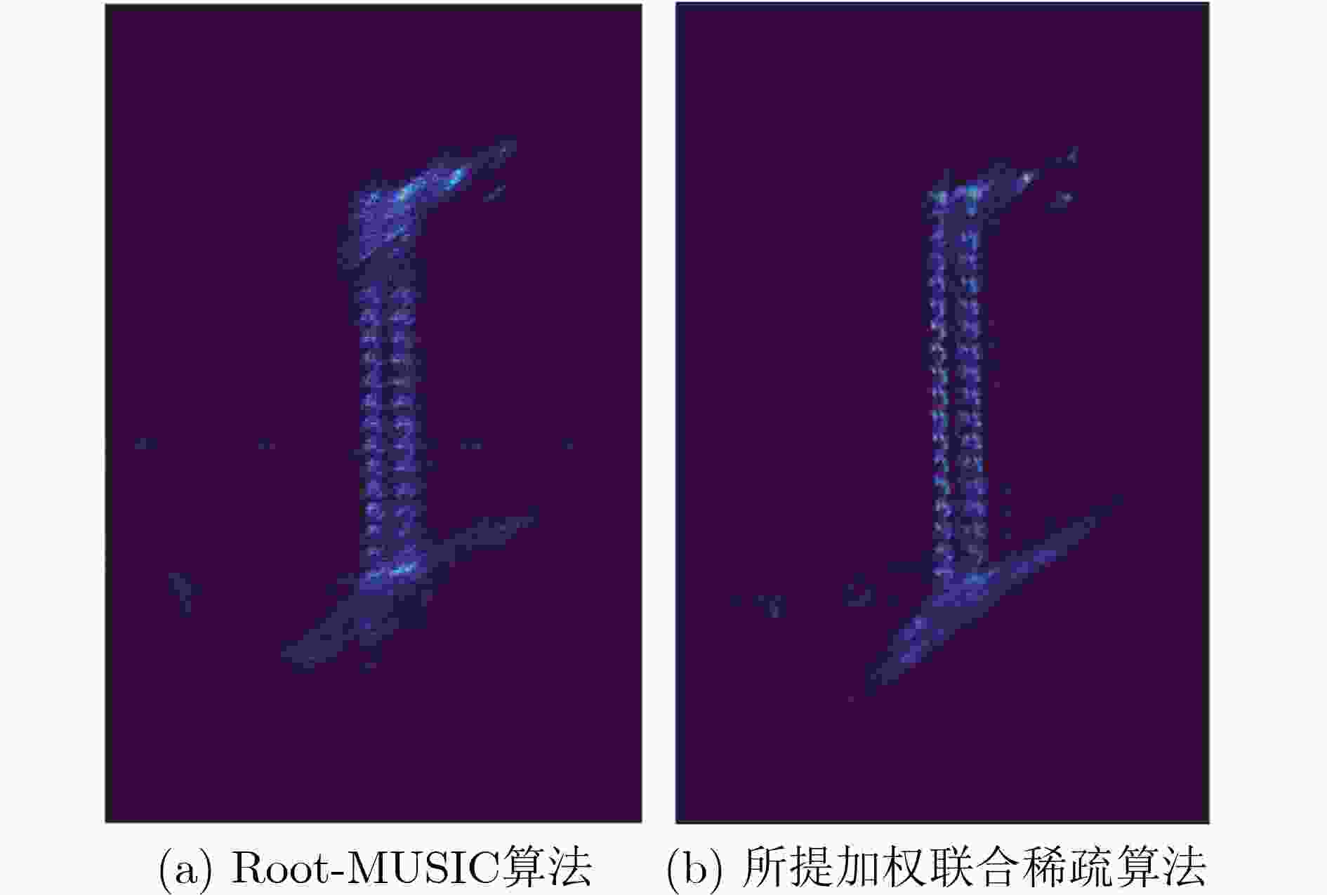
(距离×方位)成像场景海拔高度 595 m 机载平台高度 1 668 m 表 2 不同算法2维密度投影后图像熵对比
算法 图像熵 Root-MUSIC 0.564 2 所提加权联合稀疏 0.492 7 表 3 3种聚类算法的评估指标
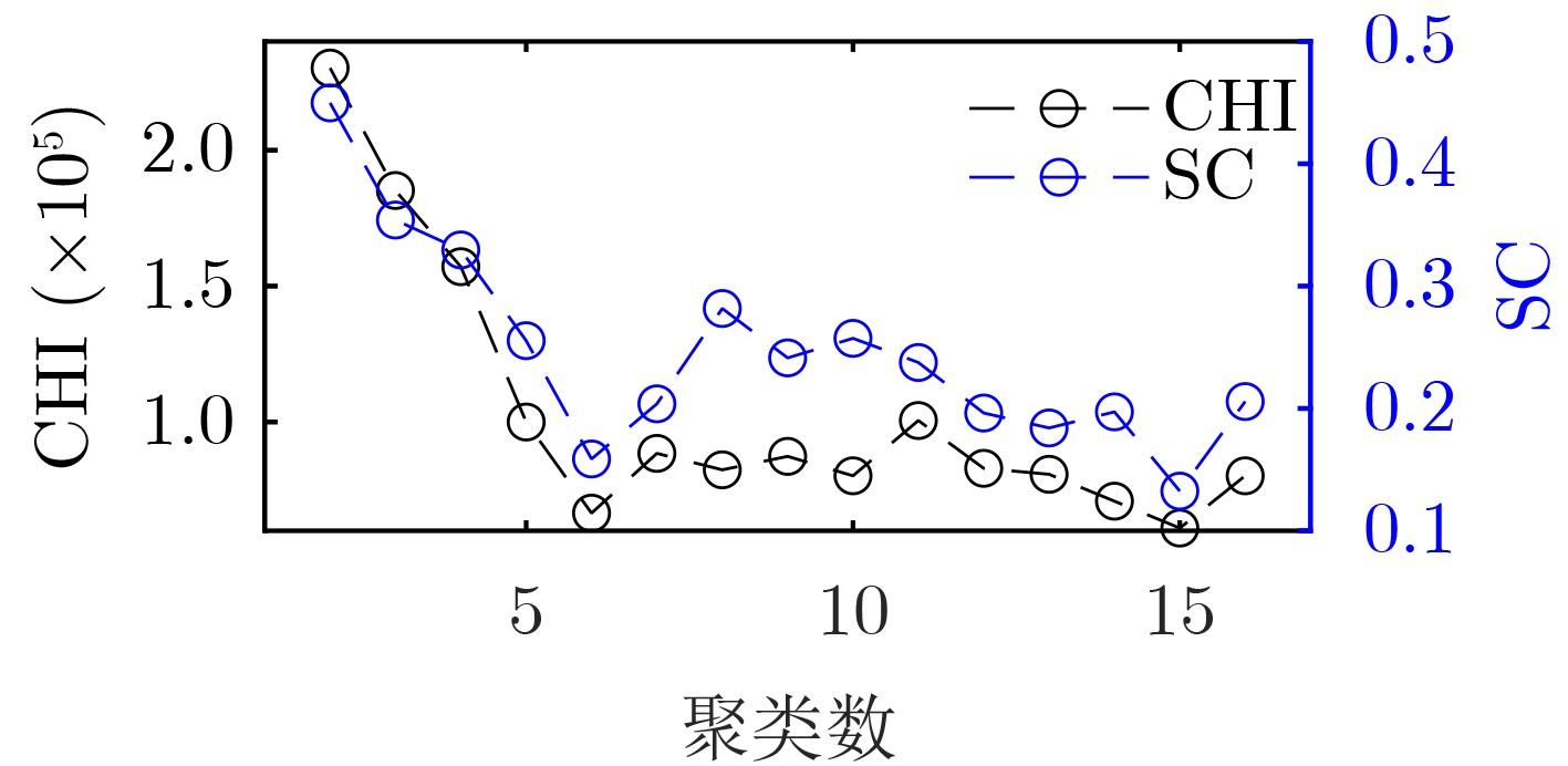
指标 K-means DBSCAN GMM 时间(s) 7.2 36.4 19.5 内存(MB) 50.9 13279.4 312.5 SC 0.4432 0.4342 0.2548 CHI 240276.4 195108.6 78216.9 -
[1] ZHANG Bangjie, XU Gang, ZHOU Rui, et al. Multi-channel back-projection algorithm for mmWave automotive MIMO SAR imaging with Doppler-division multiplexing[J]. IEEE Journal of Selected Topics in Signal Processing, 2023, 17(2): 445–457. doi: 10.1109/JSTSP.2022.3207902. [2] ZHANG Bangjie, XU Gang, YU Hanwen, et al. Array 3-D SAR tomography using robust gridless compressed sensing[J]. IEEE Transactions on Geoscience and Remote Sensing, 2023, 61: 5205013. doi: 10.1109/TGRS.2023.3259980. [3] 任烨仙, 徐丰. 若干层析SAR成像方法在解叠掩性能上的对比分析[J]. 雷达学报, 2022, 11(1): 71–82. doi: 10.12000/JR21139.REN Yexian and XU Feng. Comparative experiments on separation performance of overlapping scatterers with several tomography imaging methods[J]. Journal of Radars, 2022, 11(1): 71–82. doi: 10.12000/JR21139. [4] 周良将, 汪丙南, 王亚超, 等. 机载多维度SAR航空观测系统实验初步进展[J]. 电子与信息学报, 2023, 45(4): 1243–1253. doi: 10.11999/JEIT220250.ZHOU Liangjiang, WANG Bingnan, WANG Yachao, et al. Preliminary process of airborne multidimensional space joint-observation SAR system[J]. Journal of Electronics & Information Technology, 2023, 45(4): 1243–1253. doi: 10.11999/JEIT220250. [5] 仇晓兰, 焦泽坤, 彭凌霄, 等. SARMV3D-1.0: SAR微波视觉三维成像数据集[J]. 雷达学报, 2021, 10(4): 485–498. doi: 10.12000/JR21112.QIU Xiaolan, JIAO Zekun, PENG Lingxiao, et al. SARMV3D-1.0: Synthetic aperture radar microwave vision 3D imaging dataset[J]. Journal of Radars, 2021, 10(4): 485–498. doi: 10.12000/JR21112. [6] ZHU Xiaoxiang and BAMLER R. Super-resolution power and robustness of compressive sensing for spectral estimation with application to spaceborne tomographic SAR[J]. IEEE Transactions on Geoscience and Remote Sensing, 2012, 50(1): 247–258. doi: 10.1109/TGRS.2011.2160183. [7] REN Yexian, XIAO Aoran, HU Fengming, et al. Coprime sensing for airborne array interferometric SAR tomography[J]. IEEE Transactions on Geoscience and Remote Sensing, 2022, 60: 5229615. doi: 10.1109/TGRS.2022.3182980. [8] ZHU Xiaoxiang, GE Nan, and SHAHZAD M. Joint sparsity in SAR tomography for urban mapping[J]. IEEE Journal of Selected Topics in Signal Processing, 2015, 9(8): 1498–1509. doi: 10.1109/JSTSP.2015.2469646. [9] SHI Yilei, ZHU Xiaoxiang, and BAMLER R. Nonlocal compressive sensing-based SAR tomography[J]. IEEE Transactions on Geoscience and Remote Sensing, 2019, 57(5): 3015–3024. doi: 10.1109/TGRS.2018.2879382. [10] JIAO Zekun, DING Chibiao, QIU Xiaolan, et al. Urban 3D imaging using airborne TomoSAR: Contextual information-based approach in the statistical way[J]. ISPRS Journal of Photogrammetry and Remote Sensing, 2020, 170: 127–141. doi: 10.1016/j.isprsjprs.2020.10.013. [11] 李杭, 梁兴东, 张福博, 等. 基于高斯混合聚类的阵列干涉SAR三维成像[J]. 雷达学报, 2017, 6(6): 630–639. doi: 10.12000/JR17020.LI Hang, LIANG Xingdong, ZHANG Fubo, et al. 3D imaging for array InSAR based on Gaussian mixture model clustering[J]. Journal of Radars, 2017, 6(6): 630–639. doi: 10.12000/JR17020. [12] ERTIN E, AUSTIN C D, SHARMA S, et al. GOTCHA experience report: Three-dimensional SAR imaging with complete circular apertures[C]. SPIE 6568, Algorithms for Synthetic Aperture Radar Imagery XIV, Orlando, USA, 2007: 656802. doi: 10.1117/12.723245. [13] ZHU Xiaoxiang and SHAHZAD M. Facade reconstruction using Multiview spaceborne TomoSAR point clouds[J]. IEEE Transactions on Geoscience and Remote Sensing, 2014, 52(6): 3541–3552. doi: 10.1109/TGRS.2013.2273619. [14] SHAHZAD M and ZHU Xiaoxiang. Automatic detection and reconstruction of 2-D/3-D building shapes from spaceborne TomoSAR point clouds[J]. IEEE Transactions on Geoscience and Remote Sensing, 2016, 54(3): 1292–1310. doi: 10.1109/TGRS.2015.2477429. [15] ZHANG Wei, WANG Ping, HE Ningyu, et al. Super resolution DOA based on relative motion for FMCW automotive radar[J]. IEEE Transactions on Vehicular Technology, 2020, 69(8): 8698–8709. doi: 10.1109/TVT.2020.2999640. [16] DANIEL J W. The conjugate gradient method for linear and nonlinear operator equations[J]. SIAM Journal on Numerical Analysis, 1967, 4(1): 10–26. doi: 10.1137/0704002. [17] LIU Zhiheng, ZHANG Wenjie, YU Hang, et al. Improved YOLOv5s for small ship detection with optical remote sensing images[J]. IEEE Geoscience and Remote Sensing Letters, 2023, 20: 8002205. doi: 10.1109/LGRS.2023.3319025. [18] LIU Wenxuan, JIN Taoyong, LI Jiancheng, et al. Adaptive clustering-based method for ICESat-2 sea ice retrieval[J]. IEEE Transactions on Geoscience and Remote Sensing, 2023, 61: 4301814. doi: 10.1109/TGRS.2023.3287909. [19] ROUSSEEUW P J. Silhouettes: A graphical aid to the interpretation and validation of cluster analysis[J]. Journal of Computational and Applied Mathematics, 1987, 20: 53–65. doi: 10.1016/0377-0427(87)90125-7. [20] CALIŃSKI T and HARABASZ J. A dendrite method for cluster analysis[J]. Communications in Statistics, 1974, 3(1): 1–27. doi: 10.1080/03610927408827101. [21] LIU Fan and DENG Yong. Determine the number of unknown targets in open world based on elbow method[J]. IEEE Transactions on Fuzzy Systems, 2021, 29(5): 986–995. doi: 10.1109/TFUZZ.2020.2966182. -


 下载:
下载:







 下载:
下载:
