Design and Verification of Retracking Estimator for Synthetic Aperture Altimeter Based on Weighted Least Squares
-
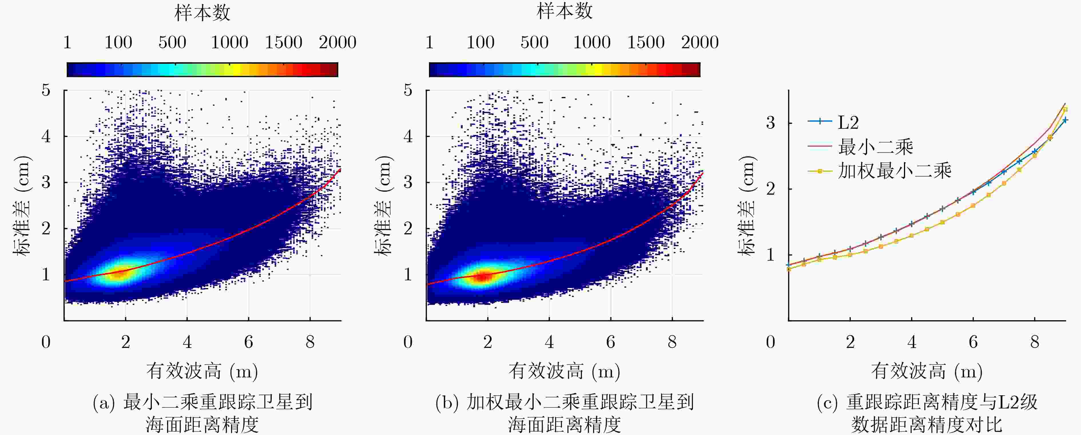
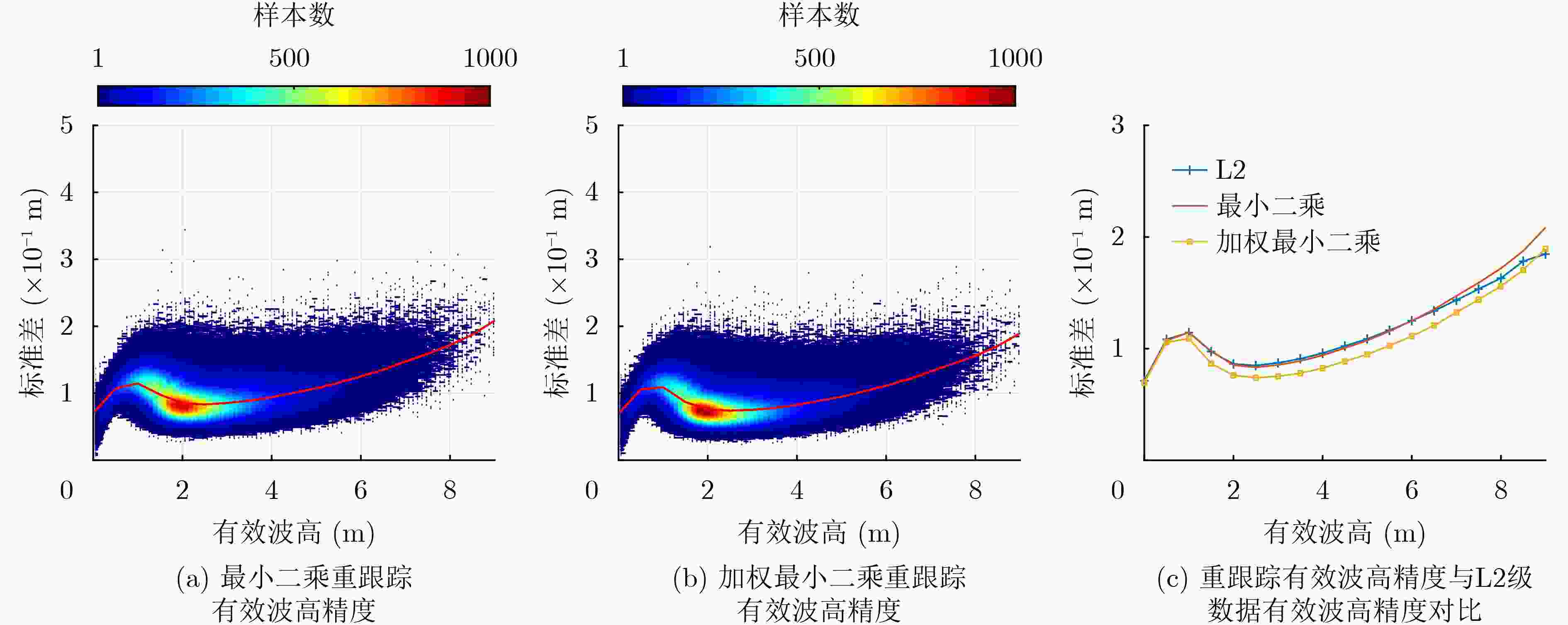
摘要: 重跟踪是提取高度计回波信号精确参数估计的重要步骤,现有的合成孔径雷达(SAR)高度计重跟踪估计器主要基于最小二乘法。该方法未考虑高度计各距离单元的统计特性不同对参数估计精度的影响,同时现有的加权最小二乘重跟踪估计器使用半解析模型,计算效率低,不利于应用于业务化。对此,该文利用合成孔径高度计解析化的合成孔径高度计研究与应用(SAMOSA)回波模型设计了新的加权方法,通过加权处理使高度计各距离单元的统计特性达到一致,进而提高了重跟踪估计器的测距和有效波高估计精度。该文利用Sentinel-3A卫星数据进行了验证,验证结果也表明了测距和有效波高这两个参数的估计精度均有提高:在2 m有效波高下,测距精度提高9%,有效波高精度提高了11%;在4 m有效波高下,测距精度提高13%,有效波高精度提高了20%。
-
关键词:
- 合成孔径雷达高度计 /
- 重跟踪估计器 /
- 加权最小二乘 /
- 合成孔径高度计研究与应用模型
Abstract: Retracking is an important step to extract accurate parameter estimation of the altimeter echo signals. The existing retracking estimators of Synthetic Aperture Radar (SAR) altimeter are mainly based on the least square method, which does not consider the influence of the different statistical characteristics of each range bin of the altimeter on the parameter estimation accuracy. At the same time, the existing weighted least squares retracking estimator uses a semi-analytical model, which is inefficient and inconvenient be applied to practice. In this paper, a new kind of weighted method is designed by using the analytical SAR Altimetry MOde Studies and Applications (SAMOSA) echo model for data processing. The weighting process makes the statistical characteristics of each range bin of the altimeter consistent, thereby improving the estimation accuracy of the range and significant wave height of the retracking estimator. The method is verified by Sentinel-3A satellite data, and the verification results show that the estimation accuracy of the two parameters, range and significant wave height, are improved: at 2 m significant wave height, the range accuracy is improved by 9%, and the significant wave height accuracy is improved by 11%; at 4 m significant wave height, the range accuracy is improved by 13%, and the significant wave height accuracy is improved by 20%. -
表 1 加权最小二乘重跟踪距离精度提高统计
${H_{\rm{s}}}$(m) 最小二乘重跟踪距离精度(cm) 加权最小二乘重跟踪距离精度(cm) 精度提升(%) 2 1.1 1.0 9 4 1.5 1.3 13 6 2.0 1.7 15 表 2 加权最小二乘重跟踪有效波高精度提高统计
${H_{\rm{s}}}$(m) 最小二乘重跟踪有效波高精度(m) 加权最小二乘重跟踪有效波高精度(m) 精度提升(%) 2 0.09 0.08 11 4 0.10 0.08 20 6 0.12 0.11 8 -
[1] RANEY R K. The delay/Doppler radar altimeter[J]. IEEE Transactions on Geoscience and Remote Sensing, 1998, 36(5): 1578–1588. doi: 10.1109/36.718861 [2] ANDERSEN O B, ZHANG Shengjun, SANDWELL D T, et al. The unique role of the Jason geodetic missions for high resolution gravity field and mean sea surface modelling[J]. Remote Sensing, 2021, 13(4): 646. doi: 10.3390/rs13040646 [3] MARTIN-PUIG C and RUFFINI G. SAR altimeter retracker performance bound over water surfaces[C]. 2009 IEEE International Geoscience and Remote Sensing Symposium, Cape Town, South Africa, 2009: V-449–V-452. doi: 10.1109/IGARSS.2009.5417633. [4] HALIMI A, MAILHES C, and TOURNERET J Y. Cramér-Rao bounds and estimation algorithms for delay/Doppler and conventional altimetry[C]. 21st European Signal Processing Conference (EUSIPCO 2013), Marrakech, Morocco, 2013: 1–5. [5] HALIMI A, MAILHES C, TOURNERET J Y, et al. A semi-analytical model for delay/Doppler altimetry and its estimation algorithm[J]. IEEE Transactions on Geoscience and Remote Sensing, 2014, 52(7): 4248–4258. doi: 10.1109/TGRS.2013.2280595 [6] RAY C, MARTIN-PUIG C, CLARIZIA M P, et al. SAR altimeter backscattered waveform model[J]. IEEE Transactions on Geoscience and Remote Sensing, 2015, 53(2): 911–919. doi: 10.1109/TGRS.2014.2330423 [7] 王磊. 高精度卫星雷达高度计数据处理技术研究[D]. [博士论文], 中国科学院研究生院(空间科学与应用研究中心), 2015.WANG Lei. Study on the data processing for high precision satellite radar altimeter[D]. [Ph. D. dissertation], Center for Space Science and Applied Research, Chinese Academy of Sciences, 2015. [8] DINARDO S, LUCAS B, and BENVENISTE J. Sentinel-3 STM SAR ocean retracking algorithm and SAMOSA model[C]. 2015 IEEE International Geoscience and Remote Sensing Symposium (IGARSS), Milan, Italy, 2015: 5320–5323. doi: 10.1109/IGARSS.2015.7327036. [9] MAKHOUL E, ROCA M, RAY C, et al. Evaluation of the precision of different delay-Doppler processor (DDP) algorithms using CryoSat-2 data over open ocean[J]. Advances in Space Research, 2018, 62(6): 1464–1478. doi: 10.1016/j.asr.2018.04.004 [10] FENOGLIO-MARC L, DINARDO S, SCHARROO R, et al. The German bight: A validation of CryoSat-2 altimeter data in SAR mode[J]. Advances in Space Research, 2015, 55(11): 2641–2656. doi: 10.1016/j.asr.2015.02.014 [11] KAY S M, 罗鹏飞译. 统计信号处理基础[M]. 北京: 电子工业出版社, 2014: 95–173.KAY S, LUO Pengfei, translation. Fundamentals of Statistical Signal Processing[M]. Beijing: Publishing House of Electronics Industry, 2014: 95–173. [12] KITTEL C M M, JIANG Liguang, TØTTRUP C, et al. Sentinel-3 radar altimetry for river monitoring–a catchment-scale evaluation of satellite water surface elevation from Sentinel-3A and Sentinel-3B[J]. Hydrology and Earth System Sciences, 2021, 25(1): 333–357. doi: 10.5194/hess-25-333-2021 [13] DINARDO S, FENOGLIO-MARC L, BECKER M, et al. A RIP-based SAR Retracker and its application in North East Atlantic with Sentinel-3[J]. Advances in Space Research, 2021, 68(2): 892–929. doi: 10.1016/j.asr.2020.06.004 [14] SHU Song, LIU Hongxing, BECK R A, et al. Analysis of Sentinel-3 SAR altimetry waveform retracking algorithms for deriving temporally consistent water levels over ice-covered lakes[J]. Remote Sensing of Environment, 2020, 239: 111643. doi: 10.1016/j.rse.2020.111643 [15] MOREAU T, CADIER E, BOY F, et al. High-performance altimeter Doppler processing for measuring sea level height under varying sea state conditions[J]. Advances in Space Research, 2021, 67(6): 1870–1886. doi: 10.1016/j.asr.2020.12.038 -


 下载:
下载:


 下载:
下载:
