A High-precision Water Segmentation Algorithm for SAR Image and its Application
-
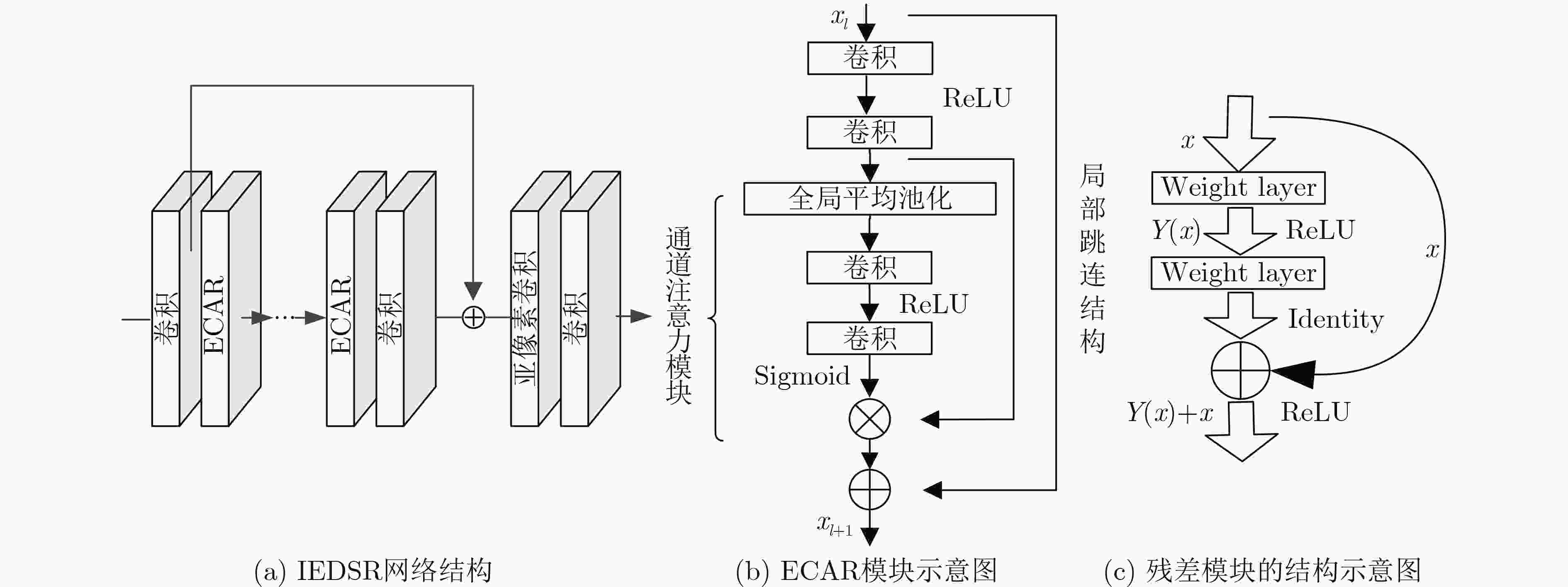
摘要: 合成孔径雷达(SAR)图像水域分割在湖泊、河流等陆地水文监测领域有重要的研究意义。由于SAR图像分辨率不足所导致的陆地与水域边界模糊, 会影响水域分割精度。该文以中国青藏高原地区的多庆错湖为研究对象,使用Sentinel-1A SAR图像数据,综合运用深度残差模型、通道注意力与亚像素卷积,提出一种基于亚像素卷积的增强型通道注意力深度残差超分辨网络,对滤波后的SAR图像进行重建、水域轮廓提取与精度分析。通过比较不同超分辨算法下的重建结果及水域轮廓提取精度,该文算法在重建效果与提取精度上都较传统方法有明显提升,并具有很好的鲁棒性。Abstract: Water segmentation of Synthetic Aperture Radar (SAR) is of great significance in land hydrological monitoring, such as lakes and rivers. Water segmentation accuracy is influenced by the blurring of the boundary between land and water region because of the insufficient resolution of SAR image. Sentinel-1A SAR image is used to study the Duoqing Co in the Tibetan Plateau of China. This paper integrates the enhanced deep residual block, channel attention mechanism and sub-pixel convolution, an enhanced channel attention deep residual network is proposed based on sub-pixel to reconstruct the filtered SAR image, extract the water contour and analyze the accuracy. By comparing the reconstruction results of different super-resolution algorithms and the accuracy of water contour extraction, this algorithm, with great robustness, is obviously better than the traditional method in both reconstruction effect and extraction accuracy.
-
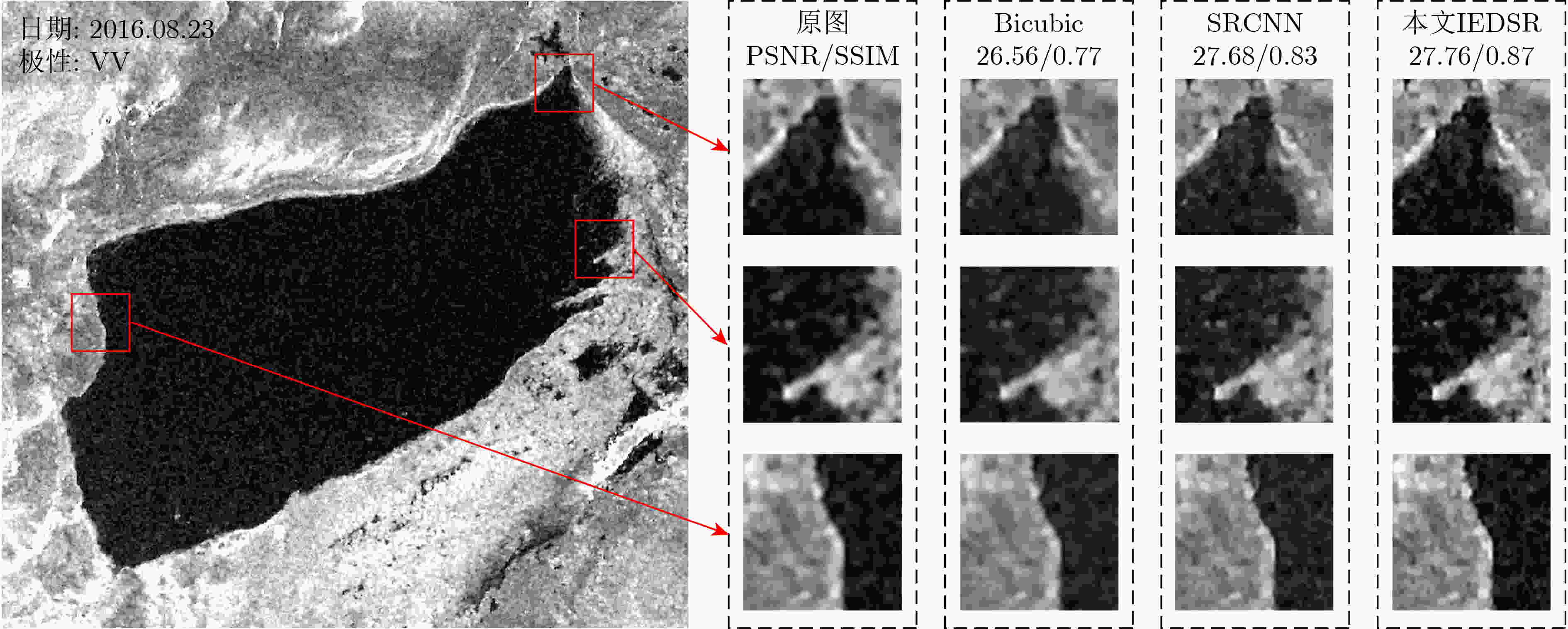
表 1 8组多庆错湖影像重建质量评估(PSNR(dB)/SSIM)
日期 Bicubic SRCNN 本文IEDSR 20150902 27.41/0.76 28.46/0.82 28.22/0.85 20151016 24.64/0.68 25.38/0.75 26.39/0.85 20151125 27.05/0.78 28.21/0.84 28.28/0.86 20160401 25.86/0.78 26.90/0.84 27.43/0.89 20160417 27.09/0.83 28.46/0.88 27.93/0.89 20160612 24.12/0.76 24.99/0.83 24.90/0.86 20160730 27.71/0.79 28.94/0.85 29.04/0.88 20160823 28.61/0.81 29.55/0.86 29.88/0.88 平均值 26.56/0.77 27.61/0.83 27.76/0.87 表 2 不同时期轮廓提取精度比较(OM(%)/COM(%)/Dis像素)
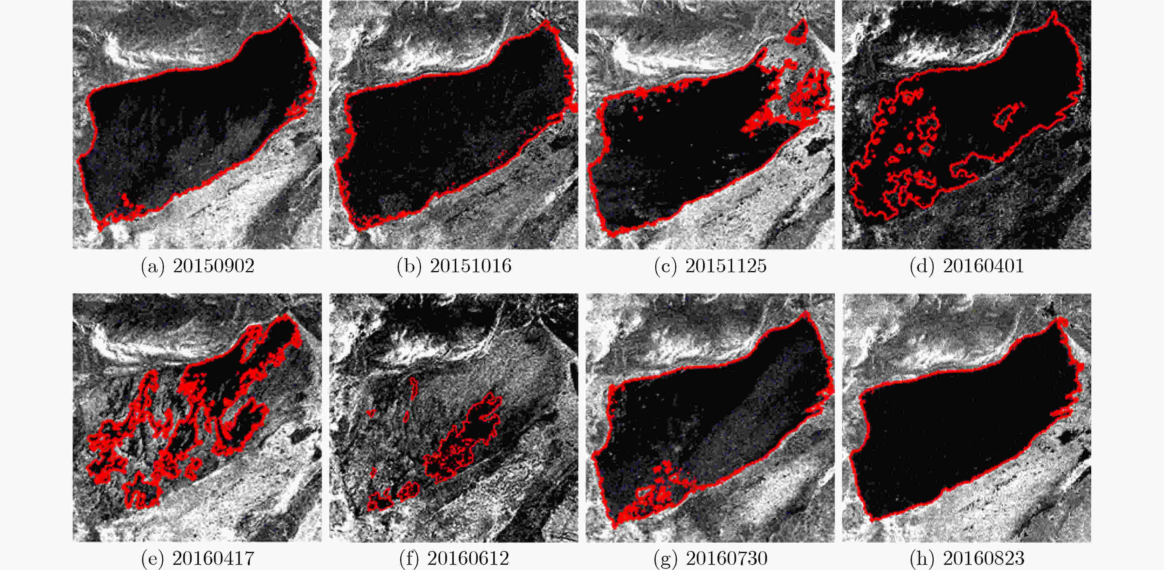
日期 原图 Bicubic SRCNN 本文IEDSR 20150902 0.39/0.29/0.73 0.26/0.13/0.44 0.22/0.11/0.35 0.14/0.13/0.29 20151016 0.26/1.14/1.03 0.22/0.56/0.61 0.18/0.64/0.60 0.05/0.78/0.60 20151125 0.12/2.83/2.32 0.17/1.14/1.03 0.08/1.24/1.01 0.02/1.24/0.97 20160401 0.12/2.74/2.25 0.19/0.88/0.83 0.08/0.93/0.77 0.01/0.64/0.51 20160417 0.28/10.57/2.96 0.50/3.84/1.80 0.43/3.24/1.50 0.02/2.44/0.99 20160612 0.62/12.93/2.70 0.61/4.41/0.89 0.48/4.43/0.86 0.04/3.15/0.55 20160730 0.23/0.54/0.77 0.13/0.28/0.41 0.05/0.51/0.57 0.01/0.28/0.30 20160823 0.16/0.30/0.52 0.01/0.11/0.22 0.09/0.05/0.15 0.05/0.08/0.10 -
朱立平, 张国庆, 杨瑞敏, 等. 青藏高原最近40年湖泊变化的主要表现与发展趋势[J]. 中国科学院院刊, 2019, 34(11): 1254–1263. doi: 10.16418/j.issn.1000-3045.2019.11.008ZHU Liping, ZHANG Guoqing, YANG Ruimin, et al. Lake variations on Tibetan plateau of recent 40 years and future changing tendency[J]. Bulletin of Chinese Academy of Sciences, 2019, 34(11): 1254–1263. doi: 10.16418/j.issn.1000-3045.2019.11.008 SONG Kaishan, LIU Ge, WANG Qiang, et al. Quantification of lake clarity in China using Landsat OLI imagery data[J]. Remote Sensing of Environment, 2020, 243: 111800. doi: 10.1016/j.rse.2020.111800 李春升, 王伟杰, 王鹏波, 等. 星载SAR技术的现状与发展趋势[J]. 电子与信息学报, 2016, 38(1): 229–240. doi: 10.11999/JEIT151116LI Chunsheng, WANG Weijie, WANG Pengbo, et al. Current situation and development trends of spaceborne SAR technology[J]. Journal of Electronics &Information Technology, 2016, 38(1): 229–240. doi: 10.11999/JEIT151116 GUO Yaru and ZHANG Jixian. A new 2D Otsu for water extraction from SAR image[J]. International Archives of the Photogrammetry, Remote Sensing and Spatial Information Sciences, 2017, XLⅡ-2/W7: 733–736. doi: 10.5194/isprs-archives-XLⅡ-2-W7-733-2017. 杜兰, 魏迪, 李璐, 等. 基于半监督学习的SAR目标检测网络[J]. 电子与信息学报, 2020, 42(1): 154–163. doi: 10.11999/JEIT190783DU Lan, WEI Di, LI Lu, et al. SAR target detection network via semi-supervised learning[J]. Journal of Electronics &Information Technology, 2020, 42(1): 154–163. doi: 10.11999/JEIT190783 冷英, 刘忠玲, 张衡, 等. 一种改进的ACM算法及其在鄱阳湖水域监测中的应用[J]. 电子与信息学报, 2017, 39(5): 1064–1070. doi: 10.11999/JEIT160870LENG Ying, LIU Zhongling, ZHANG Heng, et al. Improved ACM algorithm for Poyang lake monitoring[J]. Journal of Electronics &Information Technology, 2017, 39(5): 1064–1070. doi: 10.11999/JEIT160870 KASS M, WITKIN A, and TERZOPOULOS D. Snakes: Active contour models[J]. International Journal of Computer Vision, 1988, 1(1): 321–332. doi: 10.1007/BF00133570 LI Ning, WANG R, DENG Yunkai, et al. Waterline mapping and change detection of Tangjiashan dammed lake after Wenchuan earthquake from multitemporal high-resolution airborne SAR imagery[J]. IEEE Journal of Selected Topics in Applied Earth Observations and Remote Sensing, 2014, 7(8): 3200–3209. doi: 10.1109/JSTARS.2014.2345417 李宁, 牛世林. 基于局部超分辨重建的高精度SAR图像水域分割方法[J]. 雷达学报, 2020, 9(1): 174–184. doi: 10.12000/JR19096LI Ning and NIU Shilin. High-precision water segmentation from synthetic aperture radar images based on local super-resolution restoration technology[J]. Journal of Radars, 2020, 9(1): 174–184. doi: 10.12000/JR19096 王钢, 周若飞, 邹昳琨. 基于压缩感知理论的图像优化技术[J]. 电子与信息学报, 2020, 42(1): 222–233. doi: 10.11999/JEIT190669WANG Gang, ZHOU Ruofei, and ZOU Yikun. Research on image optimization technology based on compressed sensing[J]. Journal of Electronics &Information Technology, 2020, 42(1): 222–233. doi: 10.11999/JEIT190669 TSAI R Y and HUANG T S. Multiframe image restoration and registration[J]. Advances in Computer Vision and Image Processing, 1984, 1(2): 317–339. HARDIE R C, BARNARD K J, and ARMSTRONG E E. Joint MAP registration and high-resolution image estimation using a sequence of undersampled images[J]. IEEE Transactions on Image Processing, 1997, 6(12): 1621–1633. doi: 10.1109/83.650116 KIM J, LEE J K, and LEE K M. Accurate image super-resolution using very deep convolutional networks[C]. 2016 IEEE on Computer Vision and Pattern Recognition, Las Vegas, USA, 2016: 1646–1654. doi: 10.1109/CVPR.2016.182. 吴中海, 哈广浩, 赵根模, 等. 西藏亚东-谷露裂谷南段多庆错2016年4月异常干涸的构造成因[J]. 地球科学, 2018, 43(S2): 243–255. doi: 10.3799/dqkx.2018.204WU Zhonghai, HA Guanghao, ZHAO Genmo, et al. Tectonic analysis on abnormal dried up of Duoqing co lake of southern section of Yadong-Gulu rift in South Tibet during April, 2016[J]. Earth Science, 2018, 43(S2): 243–255. doi: 10.3799/dqkx.2018.204 CHEN Jiaqi, WANG Qingwei, WANG Jian, et al. Change detection of water index in Danjiangkou reservoir using mixed log-normal distribution based active contour model[J]. IEEE Access, 2019, 7: 95430–95442. doi: 10.1109/ACCESS.2019.2929178 DONG Chao, LOY C C, HE Kaiming, et al. Image super-resolution using deep convolutional networks[J]. IEEE Transactions on Pattern Analysis and Machine Intelligence, 2016, 38(2): 295–307. doi: 10.1109/TPAMI.2015.2439281 张金松, 邢孟道, 孙光才. 一种基于密集深度分离卷积的SAR图像水域分割算法[J]. 雷达学报, 2019, 8(3): 400–412. doi: 10.12000/JR19008ZHANG Jinsong, XING Mengdao, and SUN Guangcai. A water segmentation algorithm for SAR image based on dense depthwise separable convolution[J]. Journal of Radars, 2019, 8(3): 400–412. doi: 10.12000/JR19008 HE Kaiming, ZHANG Xiangyu, REN Shaoqing, et al. Deep residual learning for image recognition[C]. 2016 IEEE Conference on Computer Vision and Pattern Recognition, Las Vegas, USA, 2016: 770–778. doi: 10.1109/CVPR.2016.90. SZEGEDY C, IOFFE S, VANHOUCKE V, et al. Inception-v4, inception-ResNet and the impact of residual connections on learning[C]. Proceedings of the 31st AAAI Conference on Artificial Intelligence, 2016. -


 下载:
下载:


 下载:
下载:
