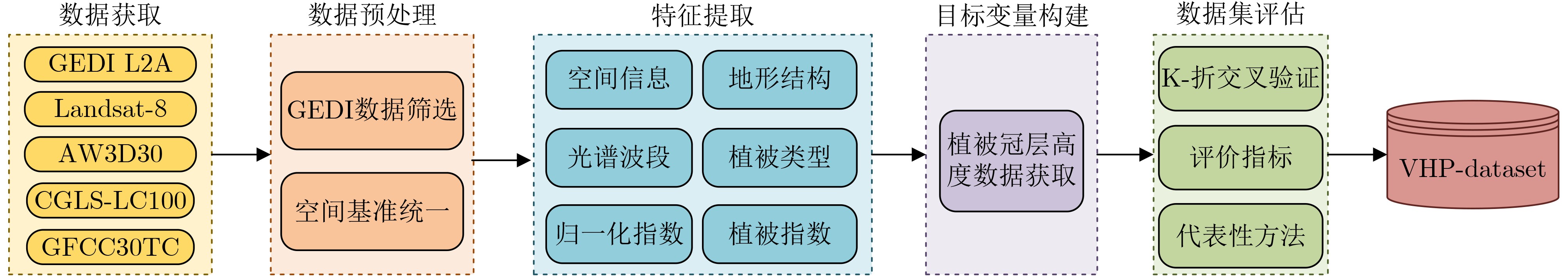
| Citation: | YU Cuilin, ZHONG Zixuan, PANG Hongyi, DING Yusheng, LAI Tao, Huang Haifeng, WANG Qingsong. Vegetation Height Prediction Dataset Oriented to Mountainous Forest Areas[J]. Journal of Electronics & Information Technology, 2025, 47(12): 5048-5060. doi: 10.11999/JEIT250941

|

| [1] |
MALAMBO L and POPESCU S. Mapping vegetation canopy height across the contiguous United States using ICESat-2 and ancillary datasets[J]. Remote Sensing of Environment, 2024, 309: 114226. doi: 10.1016/j.rse.2024.114226.
|
| [2] |
ADRAH E, WONG J P, and YIN He. Integrating GEDI, Sentinel-2, and Sentinel-1 imagery for tree crops mapping[J]. Remote Sensing of Environment, 2025, 319: 114644. doi: 10.1016/j.rse.2025.114644.
|
| [3] |
CHANG Bingtao, XIONG Hao, LI Yuan, et al. ALCSF: An adaptive and anti-noise filtering method for extracting ground and top of canopy from ICESat-2 LiDAR data along single tracks[J]. ISPRS Journal of Photogrammetry and Remote Sensing, 2024, 215: 80–98. doi: 10.1016/j.isprsjprs.2024.07.002.
|
| [4] |
BEAUDOIN A, BERNIER P Y, VILLEMAIRE P, et al. Tracking forest attributes across Canada between 2001 and 2011 using a k nearest neighbors mapping approach applied to MODIS imagery[J]. Canadian Journal of Forest Research, 2018, 48(1): 85–93. doi: 10.1139/cjfr-2017-0184.
|
| [5] |
PICKSTONE B J, GRAHAM H A, and CUNLIFFE A M. Estimating canopy height in tropical forests: Integrating airborne LiDAR and multi-spectral optical data with machine learning[J]. Sustainable Environment, 2025, 11(1): 2469406. doi: 10.1080/27658511.2025.2469406.
|
| [6] |
BENHALIMA N, OUARZEDDINE M, SOUISSI B, et al. Integrating PolInSAR and GEDI data with machine learning for forest canopy height predicting in Pongara National Park, Gabon[J]. International Journal of Remote Sensing, 2025, 46(18): 6875–6896. doi: 10.1080/01431161.2025.2549131.
|
| [7] |
POURSHAMSI M, XIA Junshi, YOKOYA N, et al. Tropical forest canopy height estimation from combined polarimetric SAR and LiDAR using machine-learning[J]. ISPRS Journal of Photogrammetry and Remote Sensing, 2021, 172: 79–94. doi: 10.1016/j.isprsjprs.2020.11.008.
|
| [8] |
LANG N, KALISCHEK N, ARMSTON J, et al. Global canopy height regression and uncertainty estimation from GEDI LIDAR waveforms with deep ensembles[J]. Remote Sensing of Environment, 2022, 268: 112760. doi: 10.1016/j.rse.2021.112760.
|
| [9] |
TOLAN J, YANG H I, NOSARZEWSKI B, et al. Very high resolution canopy height maps from RGB imagery using self-supervised vision transformer and convolutional decoder trained on aerial lidar[J]. Remote Sensing of Environment, 2024, 300: 113888. doi: 10.1016/j.rse.2023.113888.
|
| [10] |
LANG N, JETZ W, SCHINDLER K, et al. A high-resolution canopy height model of the Earth[J]. Nature Ecology & Evolution, 2023, 7(11): 1778–1789. doi: 10.1038/s41559-023-02206-6.
|
| [11] |
LEI Yuqi, WANG Yuanjia, WANG Guilong, et al. Estimating forest canopy height based on GEDI lidar data and multi-source remote sensing images[C]. The International Archives of the Photogrammetry, Remote Sensing and Spatial Information Sciences, Changsha, China, 2024: 297–303. doi: 10.5194/isprs-archives-XLVIII-1-2024-297-2024.
|
| [12] |
钱亚冠, 孔亚鑫, 陈科成, 等. 利用频谱衰减增强深度神经网络对抗迁移攻击[J]. 电子与信息学报, 2025, 47(10): 3847–3857. doi: 10.11999/JEIT250157.
QIAN Yaguan, KONG Yaxin, CHEN Kecheng, et al. Adversarial transferability attack on deep neural networks through spectral coefficient decay[J]. Journal of Electronics & Information Technology, 2025, 47(10): 3847–3857. doi: 10.11999/JEIT250157.
|
| [13] |
DEMIR I, KOPERSKI K, LINDENBAUM D, et al. DeepGlobe 2018: A challenge to parse the earth through satellite images[C]. The IEEE/CVF Conference on Computer Vision and Pattern Recognition Workshops, Salt Lake City, USA, 2018: 172–181. doi: 10.1109/CVPRW.2018.00031.
|
| [14] |
CHEN Hao and SHI Zhenwei. A spatial-temporal attention-based method and a new dataset for remote sensing image change detection[J]. Remote Sensing, 2020, 12(10): 1662. doi: 10.3390/rs12101662.
|
| [15] |
BURNS P, HAKKENBERG C R, and GOETZ S J. Multi-resolution gridded maps of vegetation structure from GEDI[J]. Scientific Data, 2024, 11(1): 881. doi: 10.1038/s41597-024-03668-4.
|
| [16] |
MIURA Y, SHAMSUDDUHA M, SUPPASRI A, et al. A global multi-sensor dataset of surface water indices from landsat-8 and sentinel-2 satellite measurements[J]. Scientific Data, 2025, 12(1): 1253. doi: 10.1038/s41597-025-05562-z.
|
| [17] |
HUANG Huabing, CHEN Peimin, XU Xiaoqing, et al. Estimating building height in China from ALOS AW3D30[J]. ISPRS Journal of Photogrammetry and Remote Sensing, 2022, 185: 146–157. doi: 10.1016/j.isprsjprs.2022.01.022.
|
| [18] |
XU Yidi, YU Le, FENG Duole, et al. Comparisons of three recent moderate resolution African land cover datasets: CGLS-LC100, ESA-S2-LC20, and FROM-GLC-Africa30[J]. International Journal of Remote Sensing, 2019, 40(16): 6185–6202. doi: 10.1080/01431161.2019.1587207.
|
| [19] |
TOWNSHEND J. Global Forest cover change (GFCC) tree cover multi-year global 30 m V003[R]. 2016. doi: 10.5067/MEaSUREs/GFCC/GFCC30TC.003.
|
| [20] |
LIU Xiaoqiang, SU Yanjun, HU Tianyu, et al. Neural network guided interpolation for mapping canopy height of China’s forests by integrating GEDI and ICESat-2 data[J]. Remote Sensing of Environment, 2022, 269: 112844. doi: 10.1016/j.rse.2021.112844.
|
| [21] |
DUNCANSON L, NEUENSCHWANDER A, HANCOCK S, et al. Biomass estimation from simulated GEDI, ICESat-2 and NISAR across environmental gradients in Sonoma County, California[J]. Remote Sensing of Environment, 2020, 242: 111779. doi: 10.1016/j.rse.2020.111779.
|
| [22] |
LIU Aobo, CHENG Xiao, and CHEN Zhuoqi. Performance evaluation of GEDI and ICESat-2 laser altimeter data for terrain and canopy height retrievals[J]. Remote Sensing of Environment, 2021, 264: 112571. doi: 10.1016/j.rse.2021.112571.
|
| [23] |
ARSHAD T and ZHANG Junping. Hierarchical attention transformer for hyperspectral image classification[J]. IEEE Geoscience and Remote Sensing Letters, 2024, 21: 5504605. doi: 10.1109/LGRS.2024.3379509.
|
| [24] |
KURANI A, DOSHI P, VAKHARIA A, et al. A comprehensive comparative study of artificial neural network (ANN) and support vector machines (SVM) on stock forecasting[J]. Annals of Data Science, 2023, 10(1): 183–208. doi: 10.1007/s40745-021-00344-x.
|
| [25] |
SALMAN H A, KALAKECH A, and STEITI A. Random forest algorithm overview[J]. Babylonian Journal of Machine Learning, 2024, 2024: 69–79. doi: 10.58496/BJML/2024/007.
|
| [26] |
DUAN Junwei. Broadfusion: A novel two-stage multifocus image fusion approach with human visual system embedded broad learning system[J]. Knowledge-Based Systems, 2025, 326: 114030. doi: 10.1016/j.knosys.2025.114030.
|
| [27] |
SAMAT A, PERSELLO C, LIU Sicong, et al. Classification of VHR multispectral images using extratrees and maximally stable extremal region-guided morphological profile[J]. IEEE Journal of Selected Topics in Applied Earth Observations and Remote Sensing, 2018, 11(9): 3179–3195. doi: 10.1109/JSTARS.2018.2824354.
|
Figures(10) / Tables(5)


 DownLoad: