| Citation: | Lin MIN, Ning WANG, Lin WU, Ning LI, Jianhui ZHAO. Inversion of Yellow River Runoff Based on Multi-source Radar Remote Sensing Technology[J]. Journal of Electronics & Information Technology, 2020, 42(7): 1590-1598. doi: 10.11999/JEIT190494

|
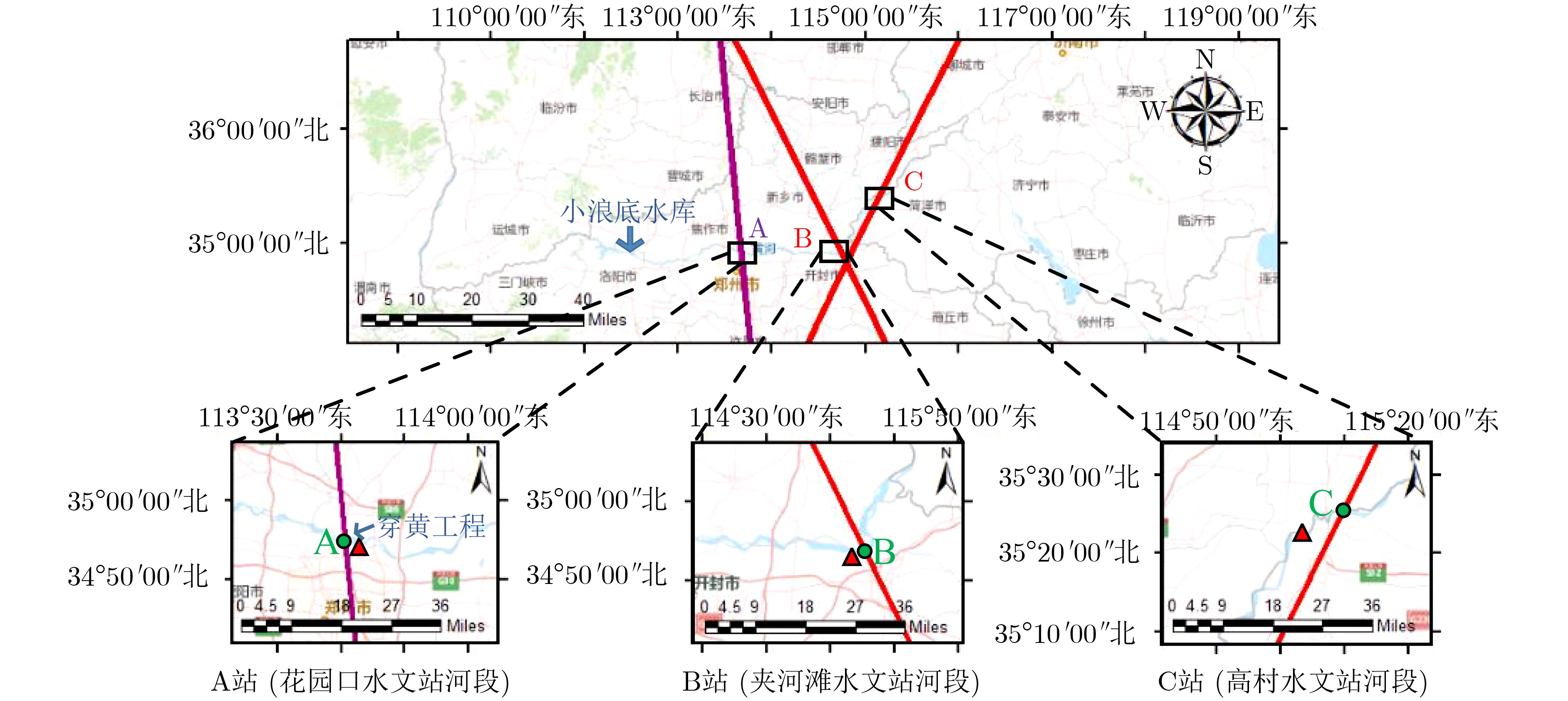
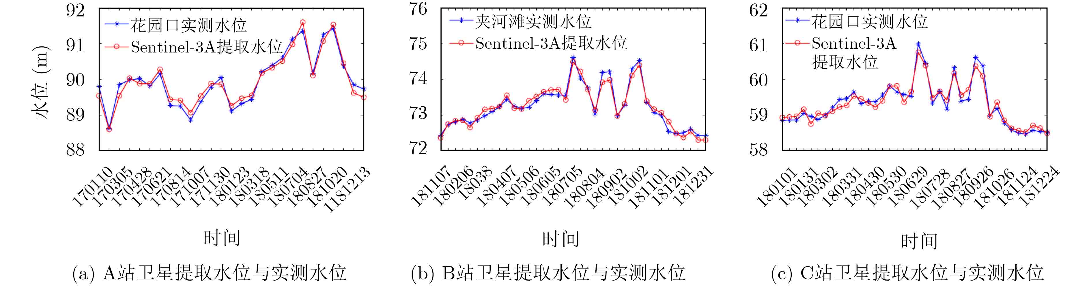
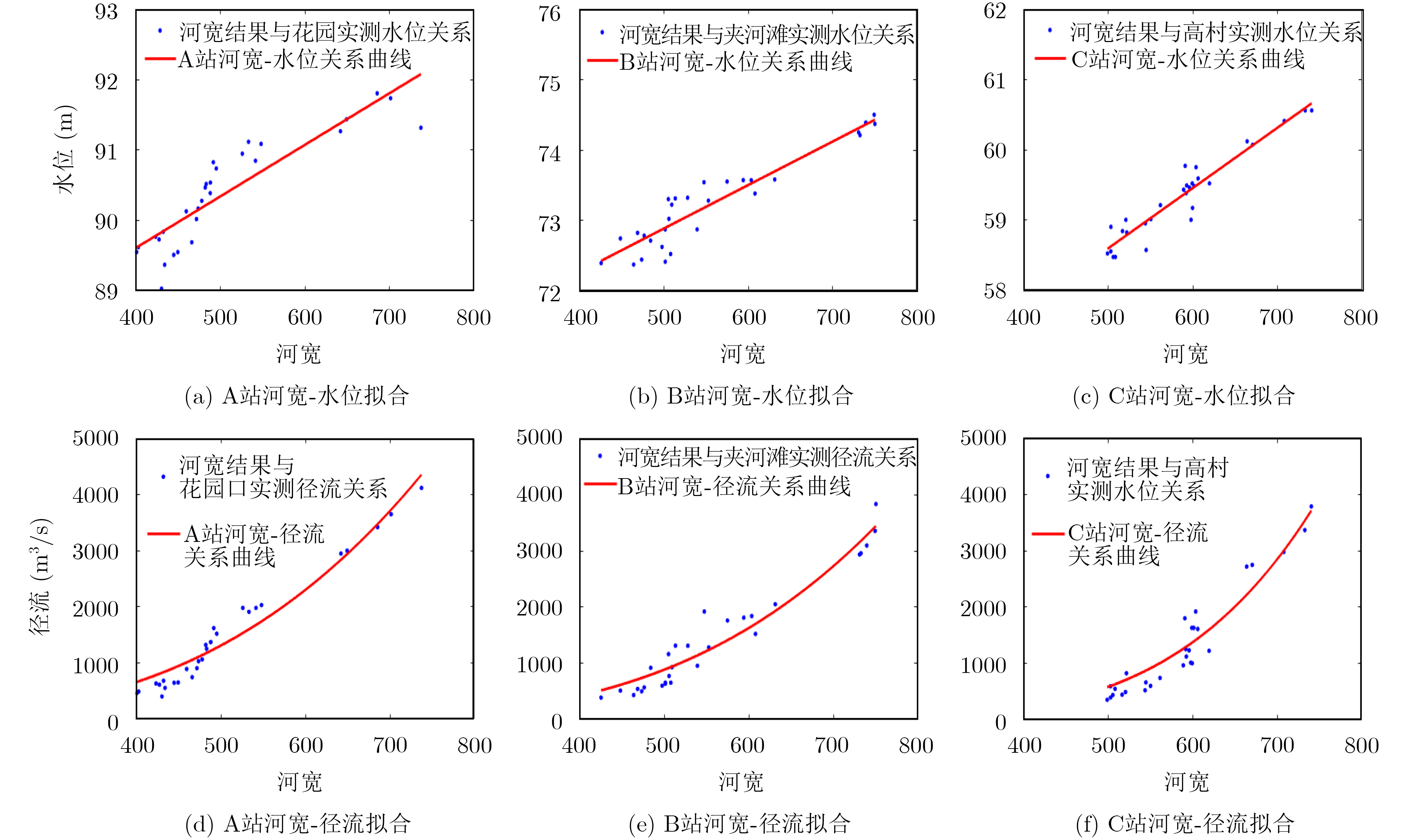
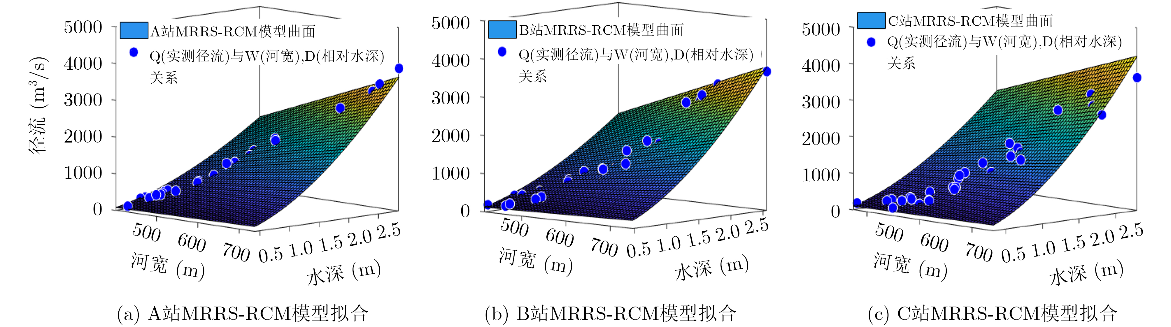
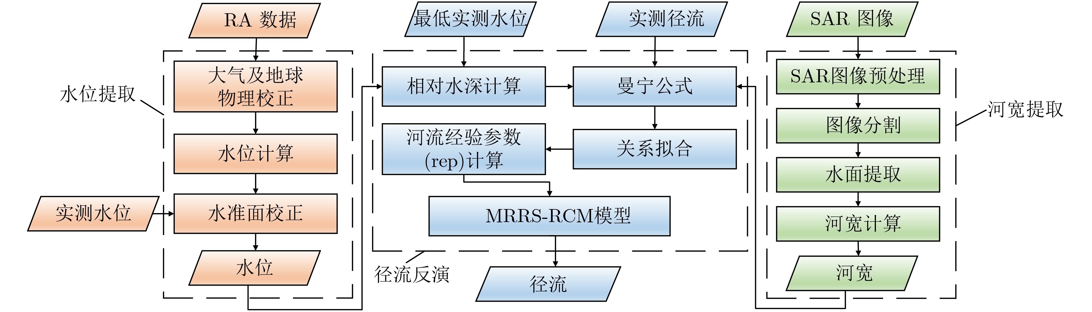
The Yellow River is an important water resource in China. Using radar remote sensing to monitor the runoff of the Yellow River can conveniently reflect the changing trend of drought and flood, which has important practical significance. At present, Radar Altimeter (RA) commonly is used to construct a water depth-runoff model in runoff inversion. This method ignores the influence of river surface change on runoff fluctuation and has certain limitations. A Multi-source Radar Remote Sensing Runoff Calculation Model (MRRS-RCM) is proposed. In this study, RA technology and Synthetic Aperture Radar (SAR) technology are used to construct MRRS-RCM model on the basis of the Manning’s equation to realize runoff inversion. Three stations are selected for experiments in the lower reaches of the Yellow River. The results show that the Relative Root Mean Square Error (RRMSE) of MRRS-RCM runoff inversion reaches 13.969%, which is better than the accuracy requirement of traditional runoff monitoring of 15%~20%.

|
张少文. 黄河流域天然年径流变化特性分析及其预测[D]. [博士论文], 四川大学, 2005.
ZHANG Shaowen. Yellow River annual runoff analysis and its forecast[D]. [Ph.D. dissertation], Sichuan University, 2005.
|
|
HUNDECHA Y and BÁRDOSSY A. Modeling of the effect of land use changes on the runoff generation of a river basin through parameter regionalization of a watershed model[J]. Journal of Hydrology, 2004, 292(1/4): 281–295. doi: 10.1016/j.jhydrol.2004.01.002
|
|
TONG Xiaohua, PAN Haiyan, XIE Huan, et al. Estimating water volume variations in Lake Victoria over the past 22 years using multi-mission altimetry and remotely sensed images[J]. Remote Sensing of Environment, 2016, 187: 400–413. doi: 10.1016/j.rse.2016.10.012
|
|
PAPA F, DURAND F, ROSSOW W B, et al. Satellite altimeter-derived monthly discharge of the Ganga-Brahmaputra River and its seasonal to interannual variations from 1993 to 2008[J]. Journal of Geophysical Research: Oceans, 2010, 115(C12): C12013. doi: 10.1029/2009JC006075
|
|
PAPA F, BALA S K, PANDEY R K, et al. Ganga - Brahmaputra river discharge from Jason-2 radar altimetry: An update to the long-term satellite-derived estimates of continental freshwater forcing flux into the Bay of Bengal[J]. Journal of Geophysical Research: Oceans, 2012, 117(C11): C11021. doi: 10.1029/2012JC008158
|
|
SICHANGI A W, WANG Lei, YANG Kun, et al. Estimating continental river basin discharges using multiple remote sensing data sets[J]. Remote Sensing of Environment, 2016, 179: 36–53. doi: 10.1016/j.rse.2016.03.019
|
|
袁翠. 基于雷达高度计的内陆水体应用研究[D]. [硕士论文], 中国科学院大学(中国科学院遥感与数字地球研究所), 2017.
YUAN Cui. Applied research on radar altimetry over inland waters[D]. [Master dissertation], University of Chinese Academy of Sciences (Institute of Remote Sensing and Digital Earth, Chinese Academy of Sciences), 2017.
|
|
WU Lin, WANG Le, MIN Lin, et al. Discrimination of algal-bloom using spaceborne SAR observations of great lakes in China[J]. Remote Sensing, 2018, 10(5): 767. doi: 10.3390/rs10050767
|
|
BRAKENRIDGE G R, KNOX J C, PAYLOR II E D, et al. Radar remote sensing aids study of the Great Flood of 1993[J]. Eos, Transactions American Geophysical Union, 1994, 75(45): 521–527. doi: 10.1029/EO075i045p00521
|
|
SMITH L C, ISACKS B L, FORSTER R R, et al. Estimation of discharge from braided glacial rivers using ERS 1 synthetic aperture radar: First results[J]. Water Resources Research, 1995, 31(5): 1325–1329. doi: 10.1029/95wr00145
|
|
冷英, 刘忠玲, 张衡, 等. 一种改进的ACM算法及其在鄱阳湖水域监测中的应用[J]. 电子与信息学报, 2017, 39(5): 1064–1070. doi: 10.11999/JEIT160870
LENG Ying, LIU Zhongling, ZHANG Heng, et al. Improved ACM algorithm for Poyang lake monitoring[J]. Journal of Electronics &Information Technology, 2017, 39(5): 1064–1070. doi: 10.11999/JEIT160870
|
|
郭拯危, 王乐, 宋国磊. 基于混合模糊的SAR图像水陆分割算法[J]. 国土资源遥感, 2018, 30(4): 62–67. doi: 10.6046/gtzyyg.2018.04.10
GUO Zhengwei, WANG Le, and SONG Guolei. SAR image land and water segmentation algorithm based on hybrid fuzzy[J]. Remote Sensing for Land &Resources, 2018, 30(4): 62–67. doi: 10.6046/gtzyyg.2018.04.10
|
|
FRAPPART F, CALMANT S, CAUHOPÉ M, et al. Preliminary results of ENVISAT RA-2-derived water levels validation over the Amazon basin[J]. Remote Sensing of Environment, 2006, 100(2): 252–264. doi: 10.1016/j.rse.2005.10.027
|
|
张胜军, 金涛勇, 褚永海, 等. Cryosat-2数据的大地水准面分辨能力研究[J]. 武汉大学学报: 信息科学版, 2016, 41(6): 759–764. doi: 10.13203/j.whugis20140829
ZHANG Shengjun, JIN Taoyong, CHU Yonghai, et al. Estimation of the resolution capability of the cryosat-2 altimeter[J]. Geomatics and Information Science of Wuhan University, 2016, 41(6): 759–764. doi: 10.13203/j.whugis20140829
|
|
BIANCAMARIA S, SCHAEDELE T, BLUMSTEIN D, et al. Validation of Jason-3 tracking modes over French rivers[J]. Remote Sensing of Environment, 2018, 209: 77–89. doi: 10.1016/j.rse.2018.02.037
|
|
CRÉTAUX J F and BIRKETT C. Lake studies from satellite radar altimetry[J]. Comptes Rendus Geoscience, 2006, 338(14/15): 1098–1112. doi: 10.1016/j.crte.2006.08.002
|
|
ZAWADZKI L and ABLAIN M. Accuracy of the mean sea level continuous record with future altimetric missions: Jason-3 vs. Sentinel-3a[J]. Ocean Science, 2016, 12(1): 9–18. doi: 10.5194/os-12-9-2016
|
|
谌华, 郭伟, 杨双宝, 等. 一种合成孔径雷达高度计定标方法[J]. 电子与信息学报, 2017, 39(9): 2232–2237. doi: 10.11999/JEIT161363
CHEN Hua, GUO Wei, YANG Shuangbao, et al. A method of calibration of SAR altimeter[J]. Journal of Electronics &Information Technology, 2017, 39(9): 2232–2237. doi: 10.11999/JEIT161363
|
|
汤玲英, 刘雯, 杨东, 等. 基于面向对象方法的Sentinel-1A SAR在洪水监测中的应用[J]. 地球信息科学学报, 2018, 20(3): 377–384. doi: 10.12082/dqxxkx.2018.170599
TANG Lingying, LIU Wen, YANG Dong, et al. Flooding monitoring application based on the object-oriented method and Sentinel-1A SAR data[J]. Journal of Geo-Information Science, 2018, 20(3): 377–384. doi: 10.12082/dqxxkx.2018.170599
|
|
张运国, 周爱春, 王爱丽. 黄河第1号洪水形成小浪底水库开闸泄洪[EB/OL]. http://www.cma.gov.cn/2011xwzx/2011xqxxw/2011xqxyw/201907/t20190702_528794.html, 2019.
ZHANG Yunguo, ZHOU Aichun and WANG Aili. The formation of No.1 flood in the Yellow River - Opening of Xiaolangdi reservoir to discharge flood[EB/OL]. http://www.cma.gov.cn/2011xwzx/2011xqxxw/2011xqxyw/201907/t20190702_528794.html, 2019.
|
Figures(8) / Tables(6)


 DownLoad: